
Browse In:
Shop by Brand: Garmin
Sort by
Items 1-
32
of 640 total
Garmin BlueChart g3 HD - HEU005R - Ireland, West Coast - microSD/SD
Garmin BlueChart g3 HD - HEU005R - Ireland, West Coast - microSD/SD
Online
$129.98for Each
Retail $129.99
Mfr PN: 010-C0764-20
Stock: 10
|
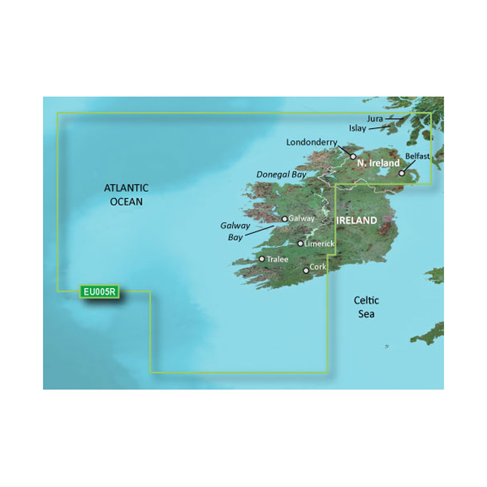
BlueChart® g3 HD - HXEU005R - Ireland, West Coast - microSD™/SD™ Coverage: The west coast of Ireland from Cork Harbour to Belfast. Also covers the Scottish coast from the Isle of Colonsay to Campbeltown Harbour. Unparalleled Coastal Chart Coverage
BlueChart g3 coastal charts provide industry-leading coverage, clarity and detail with integrated Garmin and Navionics data. Also included is Auto Guidance1 technology, which uses your desired depth and overhead clearance to calculate routes and provide a suggested path to follow — overlaid onto your chart. NOAA raster cartography is also available as a free downloadable feature via the ActiveCaptain app. It gives your chartplotter paper chartlike views of NOAA-surveyed areas in which individual points of interest are labeled with corresponding longitude and latitude information. Worldwide coverage is available by regions as accessory cards or via download; each region is sold separately. Auto Guidance Technology The Auto Guidance feature¹ calculates a suggested route using your desired depth and overhead clearance. Depth Range Shading This feature displays high-resolution Depth Range Shading for up to 10 depth ranges so you can view your designated target depth. Detailed Contours BlueChart g3 charts feature 1’ contours that provide a more accurate depiction of bottom structure for improved fishing charts and enhanced detail in swamps, canals and port plans. Shallow Water Shading To aid in navigation, Shallow Water Shading allows map shading at a user-defined depth to give a clear picture of shallow waters to avoid. NOAA Raster Cartography This feature gives your chartplotter paper chartlike views of NOAA-surveyed areas in which points of interest are labeled with corresponding longitude and latitude information. ¹Auto Guidance is for planning purposes only and does not replace safe navigation practices. Auto Guidance is not included in preloaded BlueChart g3 for ECHOMAP™ Plus series chartplotters
|
 WARNING: This product can expose you to chemicals which are known to the State of California to cause cancer, birth defects or other reproductive harm. For more information go to
 Online
$129.98for Each
Retail $129.99
Mfr PN: 010-C0764-20
Stock: 10
Garmin BlueChart g3 HD - HEU064R - Greenland - microSD/SD
Garmin BlueChart g3 HD - HEU064R - Greenland - microSD/SD
Online
$129.98for Each
Retail $129.99
Mfr PN: 010-C1001-20
Stock: 10
|
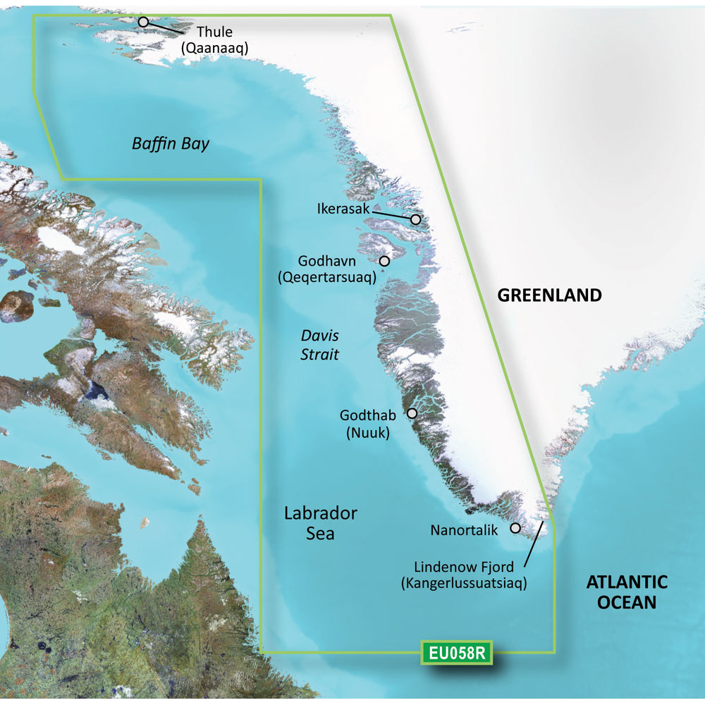
BlueChart® g3 HD - HEU064R - Greenland - microSD™/SD™ Covers: East coast. Also details Ikerasak, Holsteinsborg (Sisimiut), Godhavn (Qeqertarsuaq), Godthab (Nuuk), Julianehåb (Qaqortoq), Jameson Land, Ammassalik and Nanortalik. Unparalleled Coastal Chart Coverage
BlueChart g3 coastal charts provide industry-leading coverage, clarity and detail with integrated Garmin and Navionics data. Also included is Auto Guidance1 technology, which uses your desired depth and overhead clearance to calculate routes and provide a suggested path to follow — overlaid onto your chart. NOAA raster cartography is also available as a free downloadable feature via the ActiveCaptain app. It gives your chartplotter paper chartlike views of NOAA-surveyed areas in which individual points of interest are labeled with corresponding longitude and latitude information. Worldwide coverage is available by regions as accessory cards or via download; each region is sold separately. Auto Guidance Technology The Auto Guidance feature¹ calculates a suggested route using your desired depth and overhead clearance. Depth Range Shading This feature displays high-resolution Depth Range Shading for up to 10 depth ranges so you can view your designated target depth. Detailed Contours BlueChart g3 charts feature 1’ contours that provide a more accurate depiction of bottom structure for improved fishing charts and enhanced detail in swamps, canals and port plans. Shallow Water Shading To aid in navigation, Shallow Water Shading allows map shading at a user-defined depth to give a clear picture of shallow waters to avoid. NOAA Raster Cartography This feature gives your chartplotter paper chartlike views of NOAA-surveyed areas in which points of interest are labeled with corresponding longitude and latitude information. ¹Auto Guidance is for planning purposes only and does not replace safe navigation practices. Auto Guidance is not included in preloaded BlueChart g3 for ECHOMAP™ Plus series chartplotters
|
Online
$129.98for Each
Retail $129.99
Mfr PN: 010-C1001-20
Stock: 10
Garmin BlueChart g3 HD - HUS048R - Bermuda - microSD/SD
Garmin BlueChart g3 HD - HUS048R - Bermuda - microSD/SD
Online
$149.98for Each
Retail $149.99
Mfr PN: 010-C1024-20
Stock: 33
|
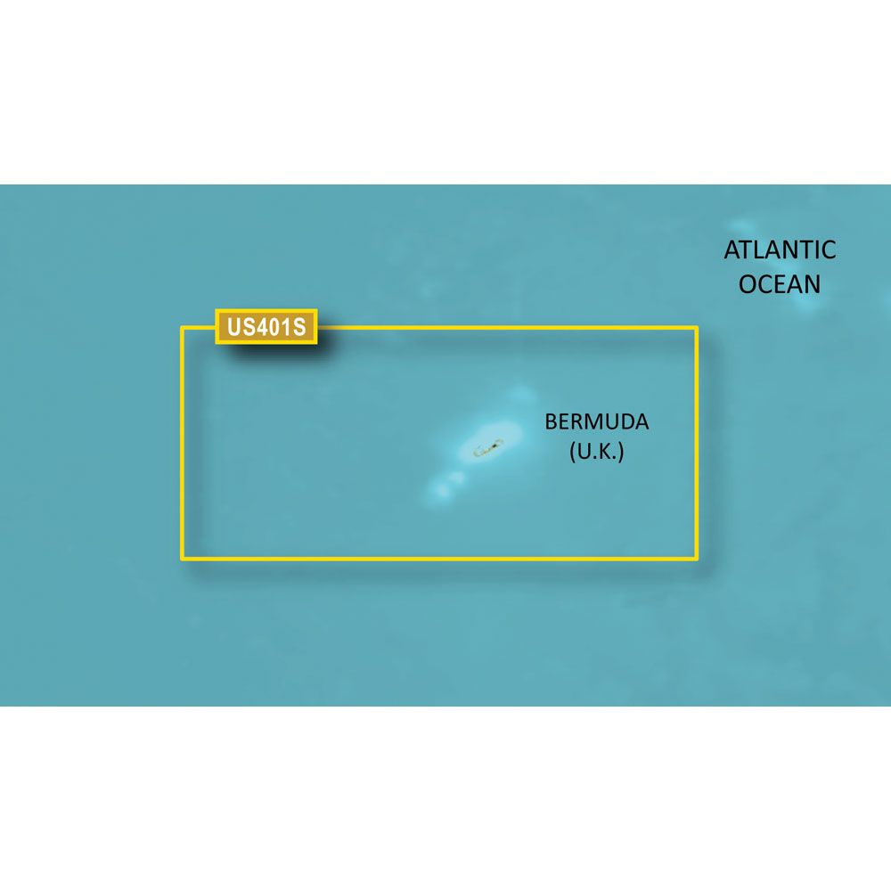
BlueChart® g3 HD - HUS048R - Bermuda - microSD™/SD™ Coverage: Provides coverage of Bermuda detailing Saint George's Island and Harbour, Harrington Sound, Somerset Island, the Great and Little Sounds, Hamilton Island, and Castle Harbour. Unparalleled Coastal Chart Coverage
BlueChart g3 coastal charts provide industry-leading coverage, clarity and detail with integrated Garmin and Navionics data. Also included is Auto Guidance¹ technology, which uses your desired depth and overhead clearance to calculate routes and provide a suggested path to follow — overlaid onto your chart. NOAA raster cartography is also available as a free downloadable feature via the ActiveCaptain app. It gives your chartplotter paper chartlike views of NOAA-surveyed areas in which individual points of interest are labeled with corresponding longitude and latitude information. Worldwide coverage is available by regions as accessory cards or via download; each region is sold separately. Auto Guidance Technology The Auto Guidance feature¹ calculates a suggested route using your desired depth and overhead clearance. Depth Range Shading This feature displays high-resolution Depth Range Shading for up to 10 depth ranges so you can view your designated target depth. Detailed Contours BlueChart g3 features up to 1’ contours, which provide a more accurate depiction of the bottom structure for improved fishing charts and navigation in swamps, canals and marinas. Shallow Water Shading To aid in navigation, Shallow Water Shading allows map shading at a user-defined depth to give a clear picture of shallow waters to avoid. NOAA Raster Cartography This feature gives your chartplotter paper chartlike views of NOAA-surveyed areas in which points of interest are labeled with corresponding longitude and latitude information. ¹Auto Guidance is for planning purposes only and does not replace safe navigation operations
|
Online
$149.98for Each
Retail $149.99
Mfr PN: 010-C1024-20
Stock: 33
Garmin BlueChart g3 HD - HXCA600X - Canada - microSD/SD
Garmin BlueChart g3 HD - HXCA600X - Canada - microSD/SD
Online
$219.98for Each
Retail $219.99
Mfr PN: 010-C1019-20
Stock: 15
|
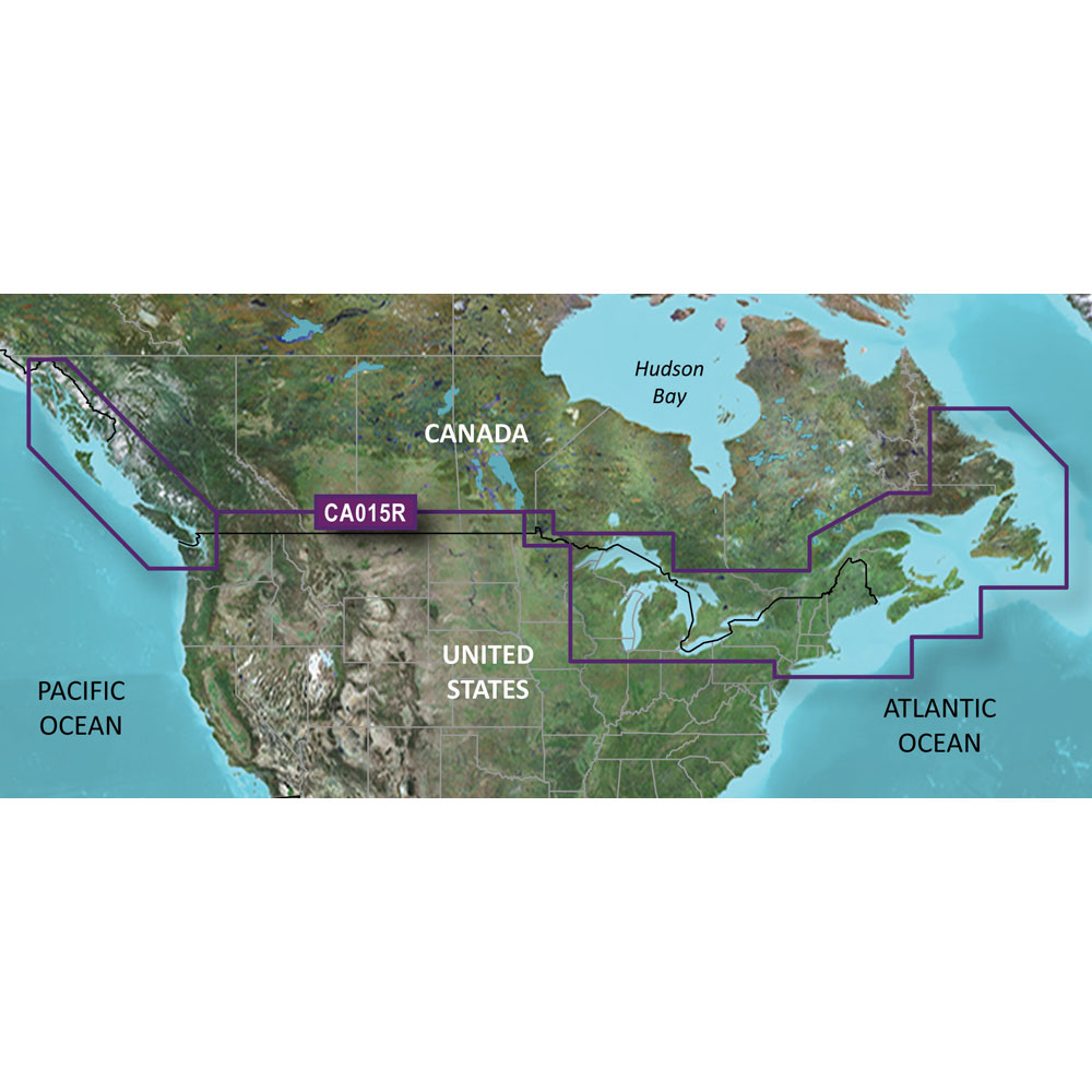
BlueChart® g3 HD - HXCA600X - Canada - microSD™/SD™ Coverage: Provides detailed coastal coverage of the North America East Coast from Nain, NL to Raritan Bay, NY featuring Newfoundland, Ile d'Anticosti, New York Harbor, and full US and Canadian coverage of the Great Lakes in their entirety. The North American West Coast is covered from Glacier Bay, AK to Aberdeen, WA featuring British Columbia, Vancouver, the Queen Charlotte Islands, and Puget Sounds. Unparalleled Coastal Chart Coverage
BlueChart g3 coastal charts provide industry-leading coverage, clarity and detail with integrated Garmin and Navionics data. Also included is Auto Guidance¹ technology, which uses your desired depth and overhead clearance to calculate routes and provide a suggested path to follow — overlaid onto your chart. NOAA raster cartography is also available as a free downloadable feature via the ActiveCaptain app. It gives your chartplotter paper chartlike views of NOAA-surveyed areas in which individual points of interest are labeled with corresponding longitude and latitude information. Worldwide coverage is available by regions as accessory cards or via download; each region is sold separately. Auto Guidance Technology The Auto Guidance feature¹ calculates a suggested route using your desired depth and overhead clearance. Depth Range Shading This feature displays high-resolution Depth Range Shading for up to 10 depth ranges so you can view your designated target depth. Detailed Contours BlueChart g3 features up to 1’ contours, which provide a more accurate depiction of the bottom structure for improved fishing charts and navigation in swamps, canals and marinas. Shallow Water Shading To aid in navigation, Shallow Water Shading allows map shading at a user-defined depth to give a clear picture of shallow waters to avoid. NOAA Raster Cartography This feature gives your chartplotter paper chartlike views of NOAA-surveyed areas in which points of interest are labeled with corresponding longitude and latitude information. ¹Auto Guidance is for planning purposes only and does not replace safe navigation operations
|
Online
$219.98for Each
Retail $219.99
Mfr PN: 010-C1019-20
Stock: 15
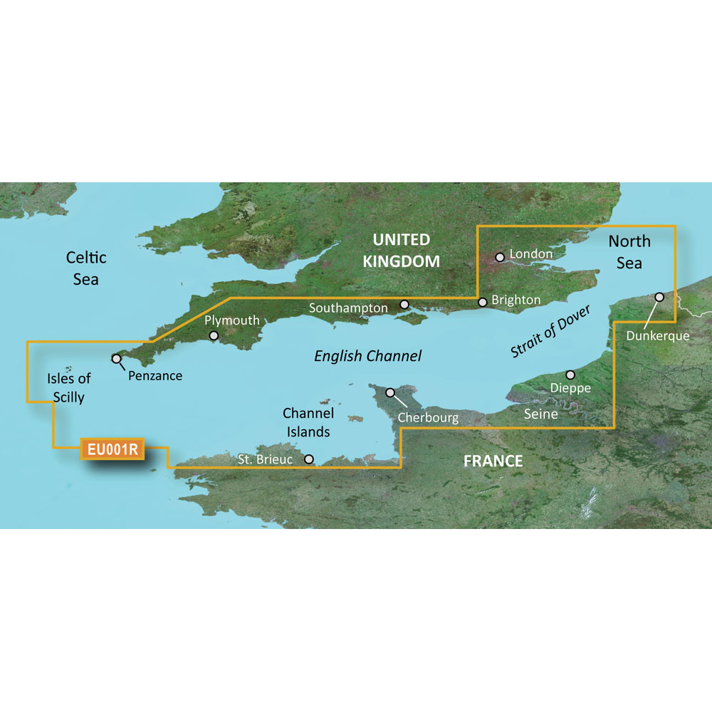
Garmin BlueChart g3 HD - HXEU001R - English Channel - microSD/SD
Garmin BlueChart g3 HD - HXEU001R - English Channel - microSD/SD
Online
$129.98for Each
Retail $129.99
Mfr PN: 010-C0760-20
Stock: 10
|
BlueChart® g3 HD - HXEU001R - English Channel - microSD™/SD™ Coverage: British coast: covers from Felixstowe to the Isles of Scilly, including Dover, The Solent, and the Isle of Wight. Also covers the River Thames from Twickenham to the North Sea. French coast: covers from Dunkerque to L'Aber Wrac'h, including Rouen and the Channel Islands Unparalleled Coastal Chart Coverage
BlueChart g3 coastal charts provide industry-leading coverage, clarity and detail with integrated Garmin and Navionics data. Also included is Auto Guidance1 technology, which uses your desired depth and overhead clearance to calculate routes and provide a suggested path to follow — overlaid onto your chart. NOAA raster cartography is also available as a free downloadable feature via the ActiveCaptain app. It gives your chartplotter paper chartlike views of NOAA-surveyed areas in which individual points of interest are labeled with corresponding longitude and latitude information. Worldwide coverage is available by regions as accessory cards or via download; each region is sold separately. Auto Guidance Technology The Auto Guidance feature¹ calculates a suggested route using your desired depth and overhead clearance. Depth Range Shading This feature displays high-resolution Depth Range Shading for up to 10 depth ranges so you can view your designated target depth. Detailed Contours BlueChart g3 charts feature 1’ contours that provide a more accurate depiction of bottom structure for improved fishing charts and enhanced detail in swamps, canals and port plans. Shallow Water Shading To aid in navigation, Shallow Water Shading allows map shading at a user-defined depth to give a clear picture of shallow waters to avoid. NOAA Raster Cartography This feature gives your chartplotter paper chartlike views of NOAA-surveyed areas in which points of interest are labeled with corresponding longitude and latitude information. ¹Auto Guidance is for planning purposes only and does not replace safe navigation practices. Auto Guidance is not included in preloaded BlueChart g3 for ECHOMAP™ Plus series chartplotters
|
Online
$129.98for Each
Retail $129.99
Mfr PN: 010-C0760-20
Stock: 10
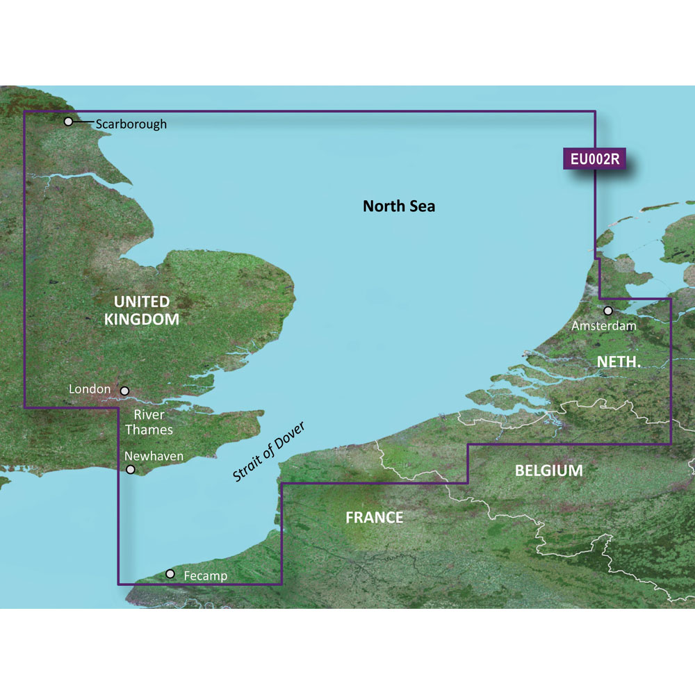
Garmin BlueChart g3 HD - HXEU002R - Dover to Amsterdam & England Southeast - microSD/SD
Garmin BlueChart g3 HD - HXEU002R - Dover to Amsterdam & England Southeast - microSD/SD
Online
$129.98for Each
Retail $129.99
Mfr PN: 010-C0761-20
Stock: 10
|
BlueChart® g3 HD - HXEU002R - Dover to Amsterdam & England Southeast - microSD™/SD™ Coverage: British coast: from Scarborough Harbour to Newhaven, including River Thames to London. Continental coast: from Amsterdam to Fecamp Unparalleled Coastal Chart Coverage
BlueChart g3 coastal charts provide industry-leading coverage, clarity and detail with integrated Garmin and Navionics data. Also included is Auto Guidance1 technology, which uses your desired depth and overhead clearance to calculate routes and provide a suggested path to follow — overlaid onto your chart. NOAA raster cartography is also available as a free downloadable feature via the ActiveCaptain app. It gives your chartplotter paper chartlike views of NOAA-surveyed areas in which individual points of interest are labeled with corresponding longitude and latitude information. Worldwide coverage is available by regions as accessory cards or via download; each region is sold separately. Auto Guidance Technology The Auto Guidance feature¹ calculates a suggested route using your desired depth and overhead clearance. Depth Range Shading This feature displays high-resolution Depth Range Shading for up to 10 depth ranges so you can view your designated target depth. Detailed Contours BlueChart g3 charts feature 1’ contours that provide a more accurate depiction of bottom structure for improved fishing charts and enhanced detail in swamps, canals and port plans. Shallow Water Shading To aid in navigation, Shallow Water Shading allows map shading at a user-defined depth to give a clear picture of shallow waters to avoid. NOAA Raster Cartography This feature gives your chartplotter paper chartlike views of NOAA-surveyed areas in which points of interest are labeled with corresponding longitude and latitude information. ¹Auto Guidance is for planning purposes only and does not replace safe navigation practices. Auto Guidance is not included in preloaded BlueChart g3 for ECHOMAP™ Plus series chartplotters
|
Online
$129.98for Each
Retail $129.99
Mfr PN: 010-C0761-20
Stock: 10
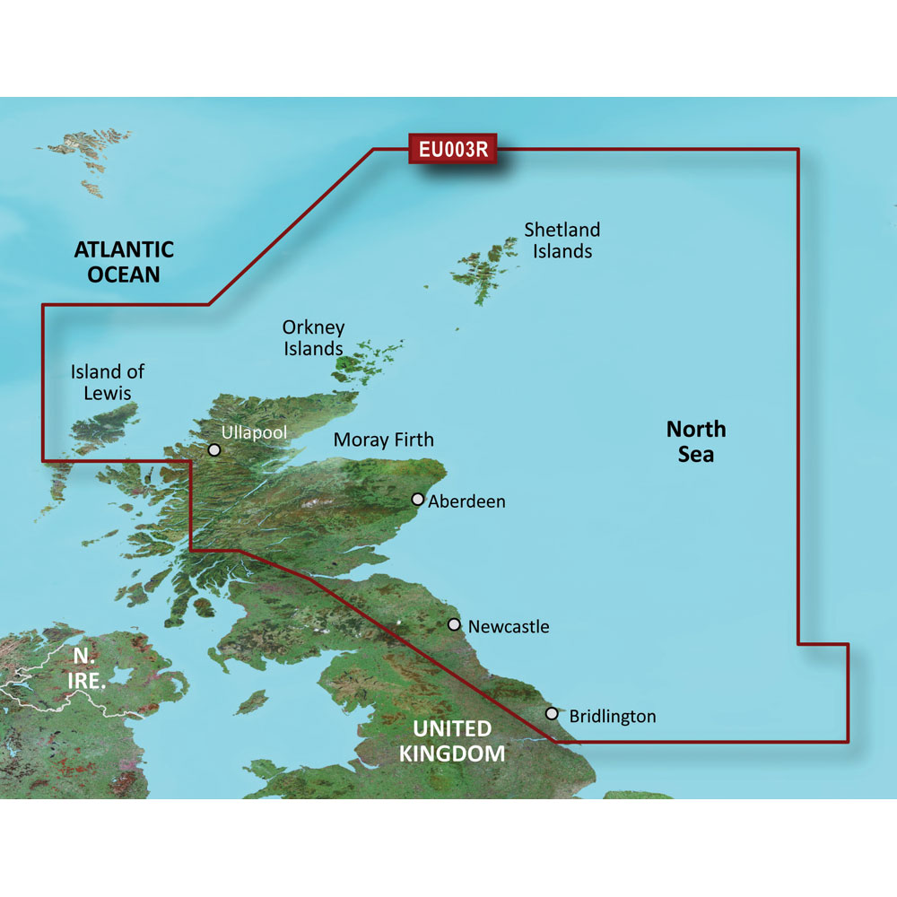
Garmin BlueChart g3 HD - HXEU003R - Great Britain Northeast Coast - microSD/SD
Garmin BlueChart g3 HD - HXEU003R - Great Britain Northeast Coast - microSD/SD
Online
$129.98for Each
Retail $129.99
Mfr PN: 010-C0762-20
Stock: 10
|
BlueChart® g3 HD - HXEU003R - Great Britain Northeast Coast - microSD™/SD™ Coverage: Covers from the Isle of Lewis, Scotland to Bridlington Harbour, England, including Gairloch, the Shetland Islands, Edinburgh, and North Sea offshore charts. Also includes the Caledonian Canal, Loch Linnhe, and Loch Ness. Unparalleled Coastal Chart Coverage
BlueChart g3 coastal charts provide industry-leading coverage, clarity and detail with integrated Garmin and Navionics data. Also included is Auto Guidance1 technology, which uses your desired depth and overhead clearance to calculate routes and provide a suggested path to follow — overlaid onto your chart. NOAA raster cartography is also available as a free downloadable feature via the ActiveCaptain app. It gives your chartplotter paper chartlike views of NOAA-surveyed areas in which individual points of interest are labeled with corresponding longitude and latitude information. Worldwide coverage is available by regions as accessory cards or via download; each region is sold separately. Auto Guidance Technology The Auto Guidance feature¹ calculates a suggested route using your desired depth and overhead clearance. Depth Range Shading This feature displays high-resolution Depth Range Shading for up to 10 depth ranges so you can view your designated target depth. Detailed Contours BlueChart g3 charts feature 1’ contours that provide a more accurate depiction of bottom structure for improved fishing charts and enhanced detail in swamps, canals and port plans. Shallow Water Shading To aid in navigation, Shallow Water Shading allows map shading at a user-defined depth to give a clear picture of shallow waters to avoid. NOAA Raster Cartography This feature gives your chartplotter paper chartlike views of NOAA-surveyed areas in which points of interest are labeled with corresponding longitude and latitude information. ¹Auto Guidance is for planning purposes only and does not replace safe navigation practices. Auto Guidance is not included in preloaded BlueChart g3 for ECHOMAP™ Plus series chartplotters
|
Online
$129.98for Each
Retail $129.99
Mfr PN: 010-C0762-20
Stock: 10
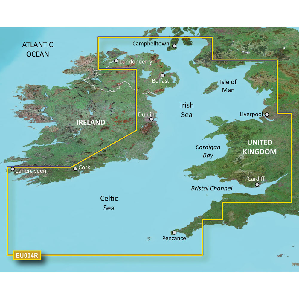
Garmin BlueChart g3 HD - HXEU004R - Irish Sea - microSD/SD
Garmin BlueChart g3 HD - HXEU004R - Irish Sea - microSD/SD
Online
$129.98for Each
Retail $129.99
Mfr PN: 010-C0763-20
Stock: 10
|
BlueChart® g3 HD - HXEU004R - Irish Sea - microSD™/SD™ Coverage: British coast: covers from Port Ellen on the Isle of Islay to Falmouth, including the Isle of Man and the Isles of Scilly. Irish coast: covers from Sheep Haven to Caherciveen, Republic of Ireland, including Londonderry, The Storks, Belfast, and Dublin. Unparalleled Coastal Chart Coverage
BlueChart g3 coastal charts provide industry-leading coverage, clarity and detail with integrated Garmin and Navionics data. Also included is Auto Guidance1 technology, which uses your desired depth and overhead clearance to calculate routes and provide a suggested path to follow — overlaid onto your chart. NOAA raster cartography is also available as a free downloadable feature via the ActiveCaptain app. It gives your chartplotter paper chartlike views of NOAA-surveyed areas in which individual points of interest are labeled with corresponding longitude and latitude information. Worldwide coverage is available by regions as accessory cards or via download; each region is sold separately. Auto Guidance Technology The Auto Guidance feature¹ calculates a suggested route using your desired depth and overhead clearance. Depth Range Shading This feature displays high-resolution Depth Range Shading for up to 10 depth ranges so you can view your designated target depth. Detailed Contours BlueChart g3 charts feature 1’ contours that provide a more accurate depiction of bottom structure for improved fishing charts and enhanced detail in swamps, canals and port plans. Shallow Water Shading To aid in navigation, Shallow Water Shading allows map shading at a user-defined depth to give a clear picture of shallow waters to avoid. NOAA Raster Cartography This feature gives your chartplotter paper chartlike views of NOAA-surveyed areas in which points of interest are labeled with corresponding longitude and latitude information. ¹Auto Guidance is for planning purposes only and does not replace safe navigation practices. Auto Guidance is not included in preloaded BlueChart g3 for ECHOMAP™ Plus series chartplotters
|
Online
$129.98for Each
Retail $129.99
Mfr PN: 010-C0763-20
Stock: 10
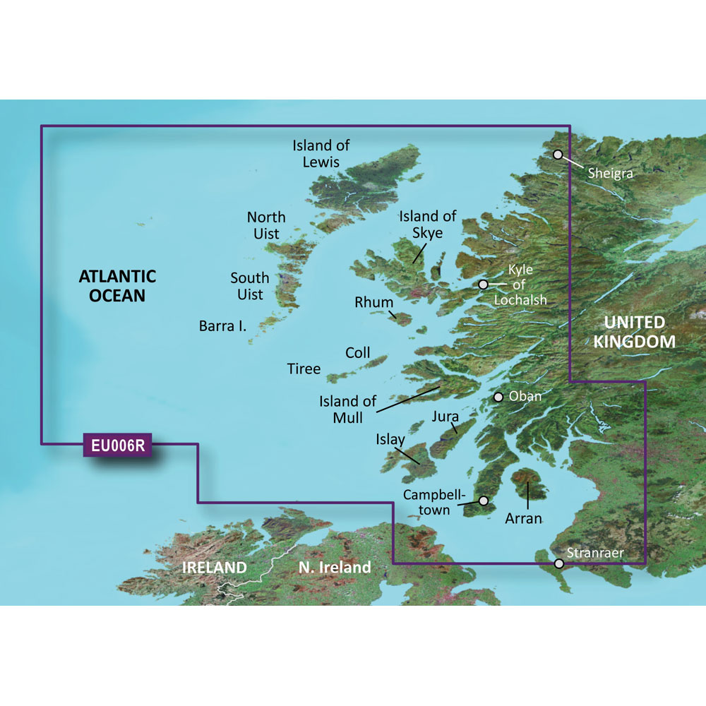
Garmin BlueChart g3 HD - HXEU006R - Scotland West Coast - microSD/SD
Garmin BlueChart g3 HD - HXEU006R - Scotland West Coast - microSD/SD
Online
$129.98for Each
Retail $129.99
Mfr PN: 010-C0765-20
Stock: 10
|
BlueChart® g3 HD - HXEU006R - Scotland West Coast - microSD™/SD™ Coverage: Scottish coast: Covers from the Isle of Lewis and Loch Bervie to Campbeltown Harbour and Girvan, including Glasgow, Ayr, and the islands of Skye, Arran, and many others. Unparalleled Coastal Chart Coverage
BlueChart g3 coastal charts provide industry-leading coverage, clarity and detail with integrated Garmin and Navionics data. Also included is Auto Guidance1 technology, which uses your desired depth and overhead clearance to calculate routes and provide a suggested path to follow — overlaid onto your chart. NOAA raster cartography is also available as a free downloadable feature via the ActiveCaptain app. It gives your chartplotter paper chartlike views of NOAA-surveyed areas in which individual points of interest are labeled with corresponding longitude and latitude information. Worldwide coverage is available by regions as accessory cards or via download; each region is sold separately. Auto Guidance Technology The Auto Guidance feature¹ calculates a suggested route using your desired depth and overhead clearance. Depth Range Shading This feature displays high-resolution Depth Range Shading for up to 10 depth ranges so you can view your designated target depth. Detailed Contours BlueChart g3 charts feature 1’ contours that provide a more accurate depiction of bottom structure for improved fishing charts and enhanced detail in swamps, canals and port plans. Shallow Water Shading To aid in navigation, Shallow Water Shading allows map shading at a user-defined depth to give a clear picture of shallow waters to avoid. NOAA Raster Cartography This feature gives your chartplotter paper chartlike views of NOAA-surveyed areas in which points of interest are labeled with corresponding longitude and latitude information. ¹Auto Guidance is for planning purposes only and does not replace safe navigation practices. Auto Guidance is not included in preloaded BlueChart g3 for ECHOMAP™ Plus series chartplotters
|
Online
$129.98for Each
Retail $129.99
Mfr PN: 010-C0765-20
Stock: 10
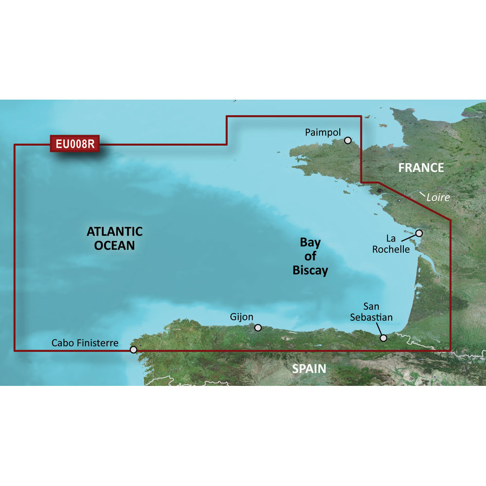
Garmin BlueChart g3 HD - HXEU008R - Bay of Biscay - microSD/SD
Garmin BlueChart g3 HD - HXEU008R - Bay of Biscay - microSD/SD
Online
$129.98for Each
Retail $129.99
Mfr PN: 010-C0766-20
Stock: 10
|
BlueChart® g2 HD - HXEU008R - Bay of Biscay - microSD™/SD™ Coverage: From Binic, France to Cabo Finisterre, Spain. Unparalleled Coastal Chart Coverage
BlueChart g3 coastal charts provide industry-leading coverage, clarity and detail with integrated Garmin and Navionics data. Also included is Auto Guidance1 technology, which uses your desired depth and overhead clearance to calculate routes and provide a suggested path to follow — overlaid onto your chart. NOAA raster cartography is also available as a free downloadable feature via the ActiveCaptain app. It gives your chartplotter paper chartlike views of NOAA-surveyed areas in which individual points of interest are labeled with corresponding longitude and latitude information. Worldwide coverage is available by regions as accessory cards or via download; each region is sold separately. Auto Guidance Technology The Auto Guidance feature¹ calculates a suggested route using your desired depth and overhead clearance. Depth Range Shading This feature displays high-resolution Depth Range Shading for up to 10 depth ranges so you can view your designated target depth. Detailed Contours BlueChart g3 charts feature 1’ contours that provide a more accurate depiction of bottom structure for improved fishing charts and enhanced detail in swamps, canals and port plans. Shallow Water Shading To aid in navigation, Shallow Water Shading allows map shading at a user-defined depth to give a clear picture of shallow waters to avoid. NOAA Raster Cartography This feature gives your chartplotter paper chartlike views of NOAA-surveyed areas in which points of interest are labeled with corresponding longitude and latitude information. ¹Auto Guidance is for planning purposes only and does not replace safe navigation practices. Auto Guidance is not included in preloaded BlueChart g3 for ECHOMAP™ Plus series chartplotters
|
Online
$129.98for Each
Retail $129.99
Mfr PN: 010-C0766-20
Stock: 10
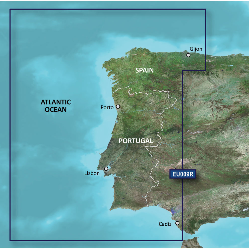
Garmin BlueChart g3 HD - HXEU009R - Portugal & Northwest Spain - microSD/SD
Garmin BlueChart g3 HD - HXEU009R - Portugal & Northwest Spain - microSD/SD
Online
$129.98for Each
Retail $129.99
Mfr PN: 010-C0767-20
Stock: 10
|
BlueChart® g3 HD - HXEU009R - Portugal & Northwest Spain - microSD™/SD™ Coverage: From Gijon to Cadiz and Sevilla, including the entire coast of Portugal. Unparalleled Coastal Chart Coverage
BlueChart g3 coastal charts provide industry-leading coverage, clarity and detail with integrated Garmin and Navionics data. Also included is Auto Guidance1 technology, which uses your desired depth and overhead clearance to calculate routes and provide a suggested path to follow — overlaid onto your chart. NOAA raster cartography is also available as a free downloadable feature via the ActiveCaptain app. It gives your chartplotter paper chartlike views of NOAA-surveyed areas in which individual points of interest are labeled with corresponding longitude and latitude information. Worldwide coverage is available by regions as accessory cards or via download; each region is sold separately. Auto Guidance Technology The Auto Guidance feature¹ calculates a suggested route using your desired depth and overhead clearance. Depth Range Shading This feature displays high-resolution Depth Range Shading for up to 10 depth ranges so you can view your designated target depth. Detailed Contours BlueChart g3 charts feature 1’ contours that provide a more accurate depiction of bottom structure for improved fishing charts and enhanced detail in swamps, canals and port plans. Shallow Water Shading To aid in navigation, Shallow Water Shading allows map shading at a user-defined depth to give a clear picture of shallow waters to avoid. NOAA Raster Cartography This feature gives your chartplotter paper chartlike views of NOAA-surveyed areas in which points of interest are labeled with corresponding longitude and latitude information. ¹Auto Guidance is for planning purposes only and does not replace safe navigation practices. Auto Guidance is not included in preloaded BlueChart g3 for ECHOMAP™ Plus series chartplotters
|
Online
$129.98for Each
Retail $129.99
Mfr PN: 010-C0767-20
Stock: 10
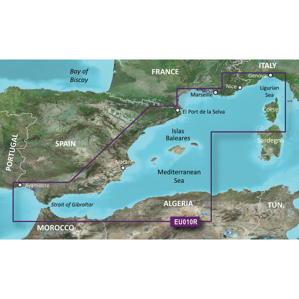
Garmin BlueChart g3 HD - HXEU010R - Spain Mediterranean Coast - microSD/SD
Garmin BlueChart g3 HD - HXEU010R - Spain Mediterranean Coast - microSD/SD
Online
$129.98for Each
Retail $129.99
Mfr PN: 010-C0768-20
Stock: 10
|
BlueChart® g3 HD - HXEU010R - Spain Mediterranean Coast - microSD™/SD™ Coverage: From El Port de la Selva to Ayamonte, including entire Spanish Mediterranean coast, Islas Baleares and Gibraltar. Unparalleled Coastal Chart Coverage
BlueChart g3 coastal charts provide industry-leading coverage, clarity and detail with integrated Garmin and Navionics data. Also included is Auto Guidance1 technology, which uses your desired depth and overhead clearance to calculate routes and provide a suggested path to follow — overlaid onto your chart. NOAA raster cartography is also available as a free downloadable feature via the ActiveCaptain app. It gives your chartplotter paper chartlike views of NOAA-surveyed areas in which individual points of interest are labeled with corresponding longitude and latitude information. Worldwide coverage is available by regions as accessory cards or via download; each region is sold separately. Auto Guidance Technology The Auto Guidance feature¹ calculates a suggested route using your desired depth and overhead clearance. Depth Range Shading This feature displays high-resolution Depth Range Shading for up to 10 depth ranges so you can view your designated target depth. Detailed Contours BlueChart g3 charts feature 1’ contours that provide a more accurate depiction of bottom structure for improved fishing charts and enhanced detail in swamps, canals and port plans. Shallow Water Shading To aid in navigation, Shallow Water Shading allows map shading at a user-defined depth to give a clear picture of shallow waters to avoid. NOAA Raster Cartography This feature gives your chartplotter paper chartlike views of NOAA-surveyed areas in which points of interest are labeled with corresponding longitude and latitude information. ¹Auto Guidance is for planning purposes only and does not replace safe navigation practices. Auto Guidance is not included in preloaded BlueChart g3 for ECHOMAP™ Plus series chartplotters
|
Online
$129.98for Each
Retail $129.99
Mfr PN: 010-C0768-20
Stock: 10
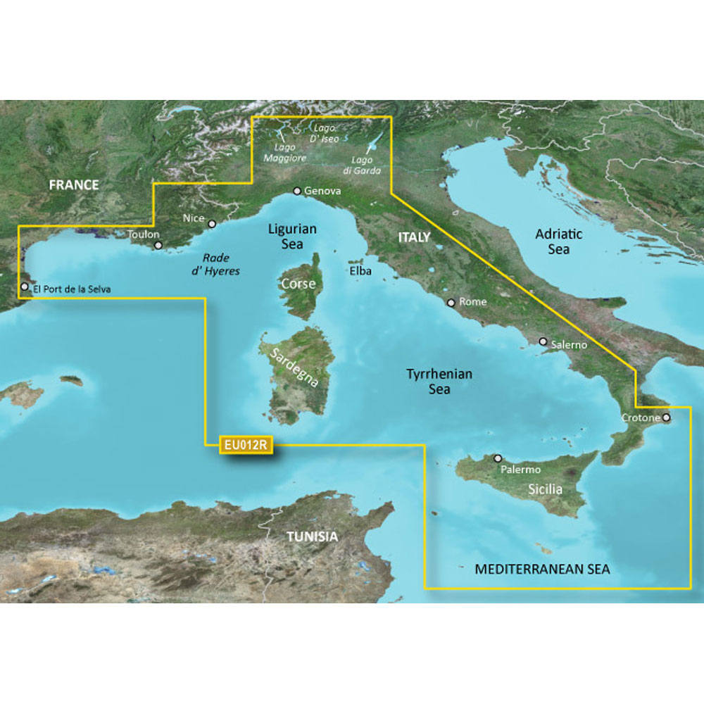
Garmin BlueChart g3 HD - HXEU012R - Italy West Coast - microSD/SD
Garmin BlueChart g3 HD - HXEU012R - Italy West Coast - microSD/SD
Online
$129.98for Each
Retail $129.99
Mfr PN: 010-C0770-20
Stock: 10
|
BlueChart® g3 HD - HXEU012R - Italy West Coast - microSD™/SD™ Coverage: From Toulon, France to Crotone, Italy, including Corse, Sardegna, and Sicilia entirely. Also includes detailed coverage of Lago Maggiore, Lago D' Iseo, and Lago di Garda in Northern Italy. Unparalleled Coastal Chart Coverage
BlueChart g3 coastal charts provide industry-leading coverage, clarity and detail with integrated Garmin and Navionics data. Also included is Auto Guidance1 technology, which uses your desired depth and overhead clearance to calculate routes and provide a suggested path to follow — overlaid onto your chart. NOAA raster cartography is also available as a free downloadable feature via the ActiveCaptain app. It gives your chartplotter paper chartlike views of NOAA-surveyed areas in which individual points of interest are labeled with corresponding longitude and latitude information. Worldwide coverage is available by regions as accessory cards or via download; each region is sold separately. Auto Guidance Technology The Auto Guidance feature¹ calculates a suggested route using your desired depth and overhead clearance. Depth Range Shading This feature displays high-resolution Depth Range Shading for up to 10 depth ranges so you can view your designated target depth. Detailed Contours BlueChart g3 charts feature 1’ contours that provide a more accurate depiction of bottom structure for improved fishing charts and enhanced detail in swamps, canals and port plans. Shallow Water Shading To aid in navigation, Shallow Water Shading allows map shading at a user-defined depth to give a clear picture of shallow waters to avoid. NOAA Raster Cartography This feature gives your chartplotter paper chartlike views of NOAA-surveyed areas in which points of interest are labeled with corresponding longitude and latitude information. ¹Auto Guidance is for planning purposes only and does not replace safe navigation practices. Auto Guidance is not included in preloaded BlueChart g3 for ECHOMAP™ Plus series chartplotters
|
Online
$129.98for Each
Retail $129.99
Mfr PN: 010-C0770-20
Stock: 10
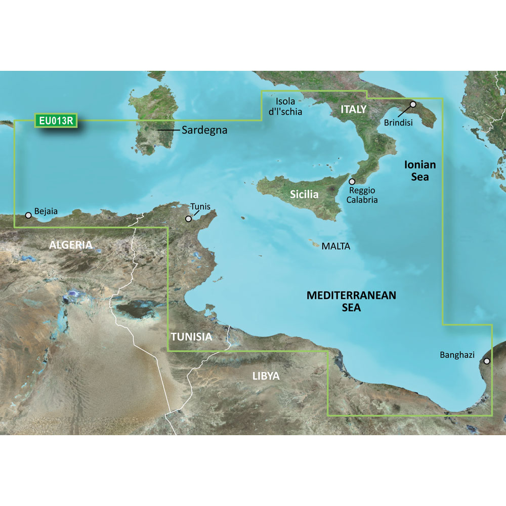
Garmin BlueChart g3 HD - HXEU013R - Italy Southwest & Tunisia - microSD/SD
Garmin BlueChart g3 HD - HXEU013R - Italy Southwest & Tunisia - microSD/SD
Online
$129.98for Each
Retail $129.99
Mfr PN: 010-C0771-20
Stock: 10
|
BlueChart® g3 HD - HXEU013R - Italy Southwest & Tunisia - microSD™/SD™ Coverage: Italian coast: from Isola d'Ischia, south to Reggio Calabria, northeast to Brindisi, including Sicilia and southern part of Sardegna. African coast: from Golfe de Bejaia, Algeria to Banghazi, Libya. Unparalleled Coastal Chart Coverage
BlueChart g3 coastal charts provide industry-leading coverage, clarity and detail with integrated Garmin and Navionics data. Also included is Auto Guidance1 technology, which uses your desired depth and overhead clearance to calculate routes and provide a suggested path to follow — overlaid onto your chart. NOAA raster cartography is also available as a free downloadable feature via the ActiveCaptain app. It gives your chartplotter paper chartlike views of NOAA-surveyed areas in which individual points of interest are labeled with corresponding longitude and latitude information. Worldwide coverage is available by regions as accessory cards or via download; each region is sold separately. Auto Guidance Technology The Auto Guidance feature¹ calculates a suggested route using your desired depth and overhead clearance. Depth Range Shading This feature displays high-resolution Depth Range Shading for up to 10 depth ranges so you can view your designated target depth. Detailed Contours BlueChart g3 charts feature 1’ contours that provide a more accurate depiction of bottom structure for improved fishing charts and enhanced detail in swamps, canals and port plans. Shallow Water Shading To aid in navigation, Shallow Water Shading allows map shading at a user-defined depth to give a clear picture of shallow waters to avoid. NOAA Raster Cartography This feature gives your chartplotter paper chartlike views of NOAA-surveyed areas in which points of interest are labeled with corresponding longitude and latitude information. ¹Auto Guidance is for planning purposes only and does not replace safe navigation practices. Auto Guidance is not included in preloaded BlueChart g3 for ECHOMAP™ Plus series chartplotters
|
Online
$129.98for Each
Retail $129.99
Mfr PN: 010-C0771-20
Stock: 10
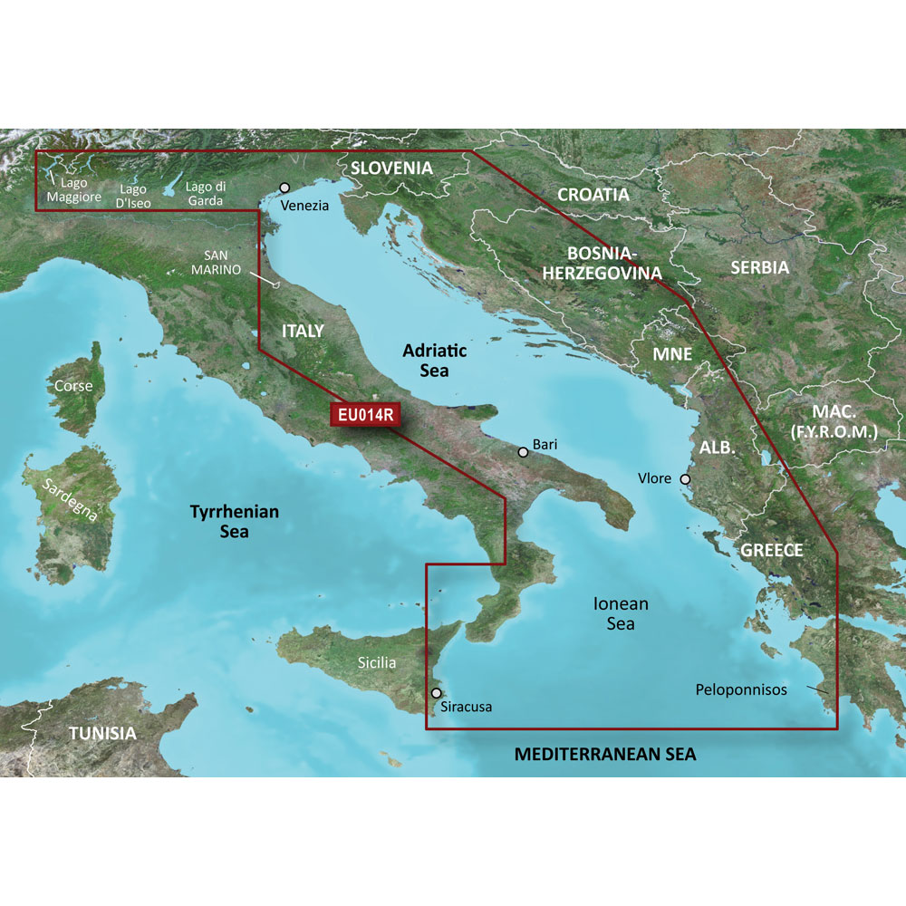
Garmin BlueChart g3 HD - HXEU014R - Italy Adriatic Sea - microSD/SD
Garmin BlueChart g3 HD - HXEU014R - Italy Adriatic Sea - microSD/SD
Online
$129.98for Each
Retail $129.99
Mfr PN: 010-C0772-20
Stock: 10
|
BlueChart® g3 HD - HXEU014R - Italy Adriatic Sea - microSD™/SD™ Coverage: Includes all of the Adriatic Sea and extends south to Siracusa, Sicilia and Gulf of Arcadia, Greece. Includes detailed coverage of Lago Maggiore, Lago d'Iseo, and Lago d'Garda in Italy. Unparalleled Coastal Chart Coverage
BlueChart g3 coastal charts provide industry-leading coverage, clarity and detail with integrated Garmin and Navionics data. Also included is Auto Guidance1 technology, which uses your desired depth and overhead clearance to calculate routes and provide a suggested path to follow — overlaid onto your chart. NOAA raster cartography is also available as a free downloadable feature via the ActiveCaptain app. It gives your chartplotter paper chartlike views of NOAA-surveyed areas in which individual points of interest are labeled with corresponding longitude and latitude information. Worldwide coverage is available by regions as accessory cards or via download; each region is sold separately. Auto Guidance Technology The Auto Guidance feature¹ calculates a suggested route using your desired depth and overhead clearance. Depth Range Shading This feature displays high-resolution Depth Range Shading for up to 10 depth ranges so you can view your designated target depth. Detailed Contours BlueChart g3 charts feature 1’ contours that provide a more accurate depiction of bottom structure for improved fishing charts and enhanced detail in swamps, canals and port plans. Shallow Water Shading To aid in navigation, Shallow Water Shading allows map shading at a user-defined depth to give a clear picture of shallow waters to avoid. NOAA Raster Cartography This feature gives your chartplotter paper chartlike views of NOAA-surveyed areas in which points of interest are labeled with corresponding longitude and latitude information. ¹Auto Guidance is for planning purposes only and does not replace safe navigation practices. Auto Guidance is not included in preloaded BlueChart g3 for ECHOMAP™ Plus series chartplotters
|
Online
$129.98for Each
Retail $129.99
Mfr PN: 010-C0772-20
Stock: 10
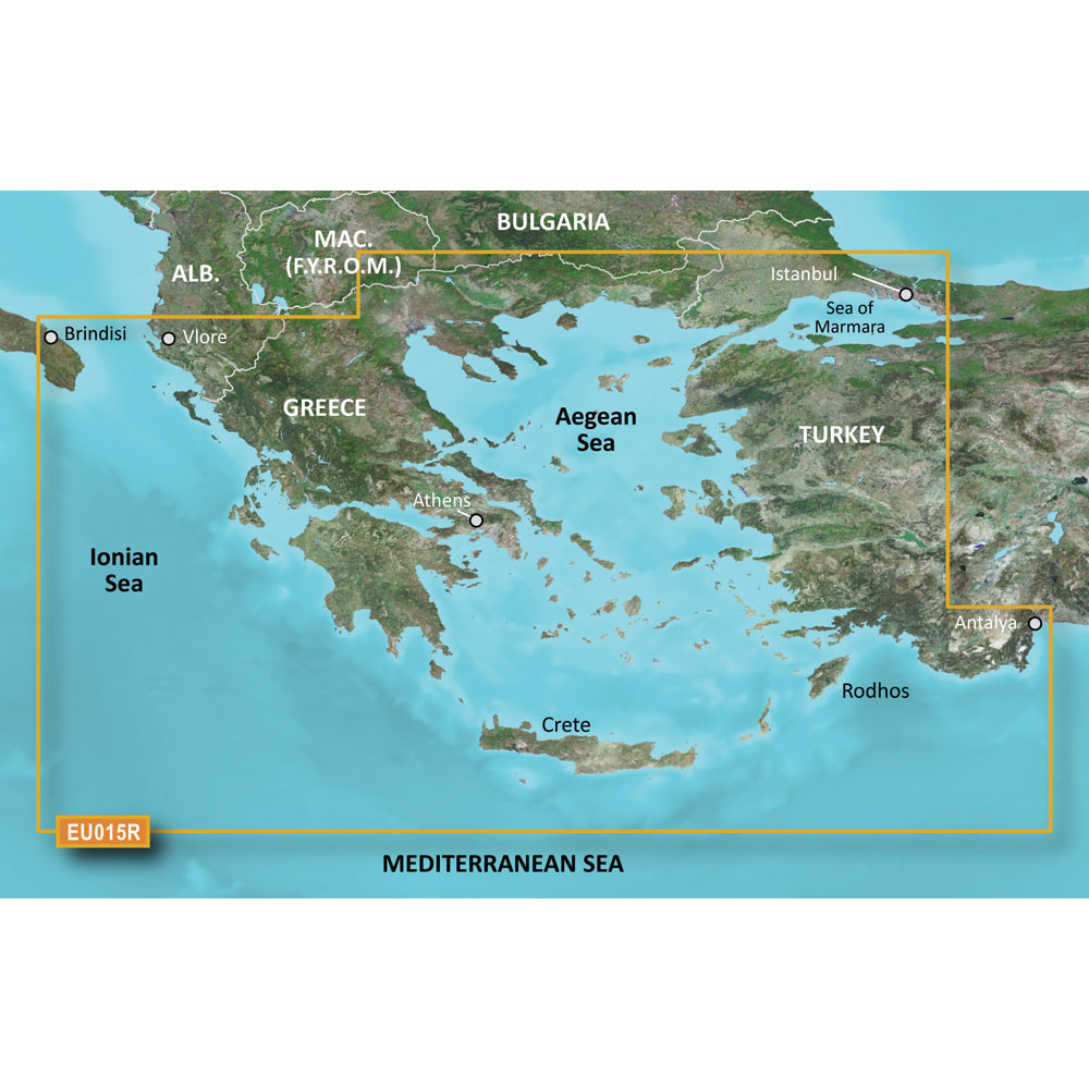
Garmin BlueChart g3 HD - HXEU015R Aegean Sea & Sea of Marmara - microSD/SD
Garmin BlueChart g3 HD - HXEU015R Aegean Sea & Sea of Marmara - microSD/SD
Online
$129.98for Each
Retail $129.99
Mfr PN: 010-C0773-20
Stock: 10
|
BlueChart® g3 HD - HXEU015R - Aegean Sea & Sea of Marmara - microSD™/SD™ Coverage: Including all of the Greek coast and Aegean Sea; Turkey from Istanbul and Sea of Marmara to Antalya; and Brindisi, Italy. Unparalleled Coastal Chart Coverage
BlueChart g3 coastal charts provide industry-leading coverage, clarity and detail with integrated Garmin and Navionics data. Also included is Auto Guidance1 technology, which uses your desired depth and overhead clearance to calculate routes and provide a suggested path to follow — overlaid onto your chart. NOAA raster cartography is also available as a free downloadable feature via the ActiveCaptain app. It gives your chartplotter paper chartlike views of NOAA-surveyed areas in which individual points of interest are labeled with corresponding longitude and latitude information. Worldwide coverage is available by regions as accessory cards or via download; each region is sold separately. Auto Guidance Technology The Auto Guidance feature¹ calculates a suggested route using your desired depth and overhead clearance. Depth Range Shading This feature displays high-resolution Depth Range Shading for up to 10 depth ranges so you can view your designated target depth. Detailed Contours BlueChart g3 charts feature 1’ contours that provide a more accurate depiction of bottom structure for improved fishing charts and enhanced detail in swamps, canals and port plans. Shallow Water Shading To aid in navigation, Shallow Water Shading allows map shading at a user-defined depth to give a clear picture of shallow waters to avoid. NOAA Raster Cartography This feature gives your chartplotter paper chartlike views of NOAA-surveyed areas in which points of interest are labeled with corresponding longitude and latitude information. ¹Auto Guidance is for planning purposes only and does not replace safe navigation practices. Auto Guidance is not included in preloaded BlueChart g3 for ECHOMAP™ Plus series chartplotters
|
Online
$129.98for Each
Retail $129.99
Mfr PN: 010-C0773-20
Stock: 10
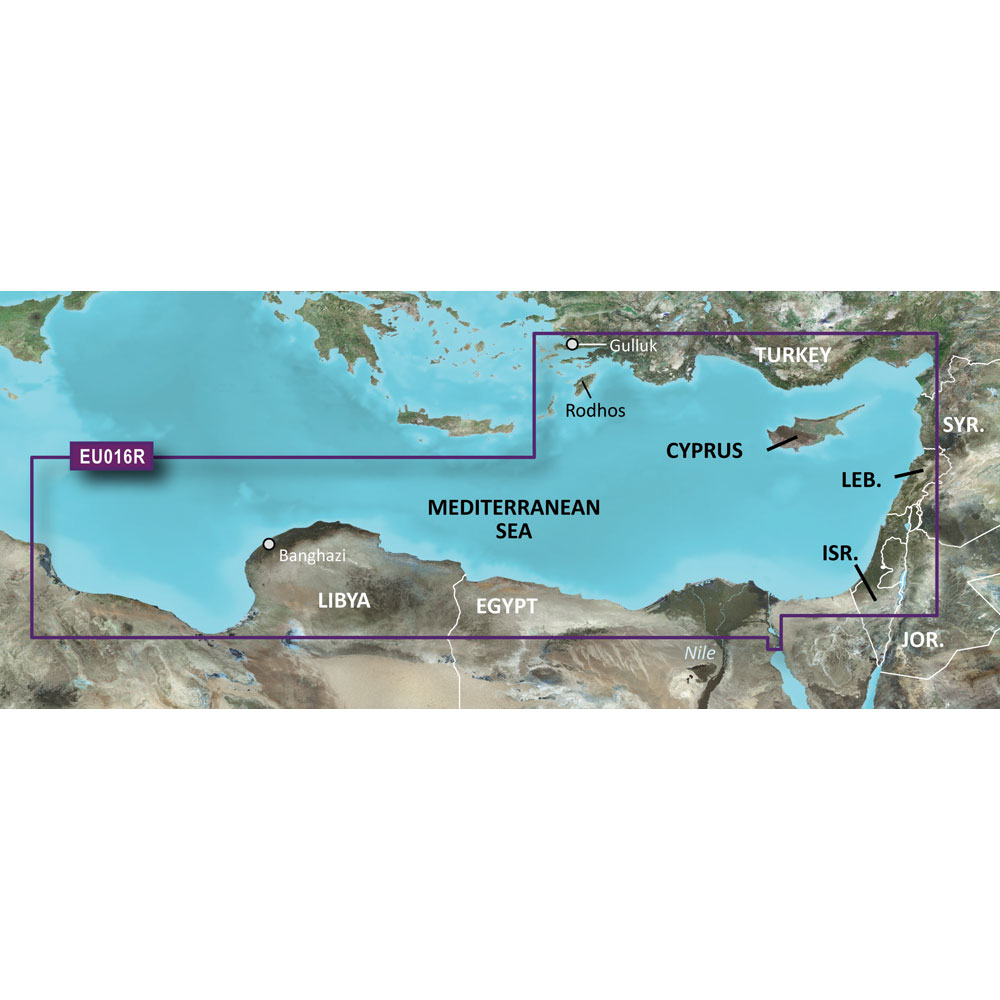
Garmin BlueChart g3 HD - HXEU016R - Mediterranean Southeast - microSD/SD
Garmin BlueChart g3 HD - HXEU016R - Mediterranean Southeast - microSD/SD
Online
$129.98for Each
Retail $129.99
Mfr PN: 010-C0774-20
Stock: 10
|
BlueChart® g3 HD - HXEU016R - Mediterranean Southeast - microSD™/SD™ Coverage: From Gulluk, Turkey east to include Cyprus, Syria, Lebanon and Israel, then west to Misratah, Libya. Unparalleled Coastal Chart Coverage
BlueChart g3 coastal charts provide industry-leading coverage, clarity and detail with integrated Garmin and Navionics data. Also included is Auto Guidance1 technology, which uses your desired depth and overhead clearance to calculate routes and provide a suggested path to follow — overlaid onto your chart. NOAA raster cartography is also available as a free downloadable feature via the ActiveCaptain app. It gives your chartplotter paper chartlike views of NOAA-surveyed areas in which individual points of interest are labeled with corresponding longitude and latitude information. Worldwide coverage is available by regions as accessory cards or via download; each region is sold separately. Auto Guidance Technology The Auto Guidance feature¹ calculates a suggested route using your desired depth and overhead clearance. Depth Range Shading This feature displays high-resolution Depth Range Shading for up to 10 depth ranges so you can view your designated target depth. Detailed Contours BlueChart g3 charts feature 1’ contours that provide a more accurate depiction of bottom structure for improved fishing charts and enhanced detail in swamps, canals and port plans. Shallow Water Shading To aid in navigation, Shallow Water Shading allows map shading at a user-defined depth to give a clear picture of shallow waters to avoid. NOAA Raster Cartography This feature gives your chartplotter paper chartlike views of NOAA-surveyed areas in which points of interest are labeled with corresponding longitude and latitude information. ¹Auto Guidance is for planning purposes only and does not replace safe navigation practices. Auto Guidance is not included in preloaded BlueChart g3 for ECHOMAP™ Plus series chartplotters
|
Online
$129.98for Each
Retail $129.99
Mfr PN: 010-C0774-20
Stock: 10
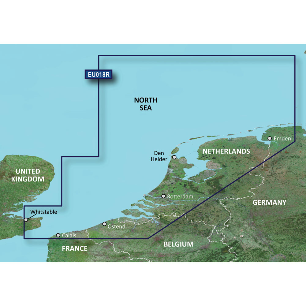
Garmin BlueChart g3 HD - HXEU018R - The Netherlands - microSD/SD
Garmin BlueChart g3 HD - HXEU018R - The Netherlands - microSD/SD
Online
$129.98for Each
Retail $129.99
Mfr PN: 010-C0775-20
Stock: 10
|
BlueChart® g3 HD - HXEU018R - The Netherlands - microSD™/SD™ Coverage: Continental coverage: from Spiekeroog, Germany to Calais, France, including The Netherlands and Belgium coast entirely. Great Britain coverage: from Whitstable to Folkestone. Unparalleled Coastal Chart Coverage
BlueChart g3 coastal charts provide industry-leading coverage, clarity and detail with integrated Garmin and Navionics data. Also included is Auto Guidance1 technology, which uses your desired depth and overhead clearance to calculate routes and provide a suggested path to follow — overlaid onto your chart. NOAA raster cartography is also available as a free downloadable feature via the ActiveCaptain app. It gives your chartplotter paper chartlike views of NOAA-surveyed areas in which individual points of interest are labeled with corresponding longitude and latitude information. Worldwide coverage is available by regions as accessory cards or via download; each region is sold separately. Auto Guidance Technology The Auto Guidance feature¹ calculates a suggested route using your desired depth and overhead clearance. Depth Range Shading This feature displays high-resolution Depth Range Shading for up to 10 depth ranges so you can view your designated target depth. Detailed Contours BlueChart g3 charts feature 1’ contours that provide a more accurate depiction of bottom structure for improved fishing charts and enhanced detail in swamps, canals and port plans. Shallow Water Shading To aid in navigation, Shallow Water Shading allows map shading at a user-defined depth to give a clear picture of shallow waters to avoid. NOAA Raster Cartography This feature gives your chartplotter paper chartlike views of NOAA-surveyed areas in which points of interest are labeled with corresponding longitude and latitude information. ¹Auto Guidance is for planning purposes only and does not replace safe navigation practices. Auto Guidance is not included in preloaded BlueChart g3 for ECHOMAP™ Plus series chartplotters
|
Online
$129.98for Each
Retail $129.99
Mfr PN: 010-C0775-20
Stock: 10
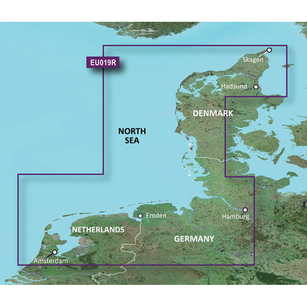
Garmin BlueChart g3 HD - HXEU019R - Alborg to Amsterdam - microSD/SD
Garmin BlueChart g3 HD - HXEU019R - Alborg to Amsterdam - microSD/SD
Online
$129.98for Each
Retail $129.99
Mfr PN: 010-C0776-20
Stock: 10
|
BlueChart® g3 HD - HXEU019R - Alborg to Amsterdam - microSD™/SD™ Coverage: Includes detailed coverage from Alborg Bugt to Amsterdam, The Netherlands, including Limfjorden, Hamburg, Bremen and Emden. Unparalleled Coastal Chart Coverage
BlueChart g3 coastal charts provide industry-leading coverage, clarity and detail with integrated Garmin and Navionics data. Also included is Auto Guidance1 technology, which uses your desired depth and overhead clearance to calculate routes and provide a suggested path to follow — overlaid onto your chart. NOAA raster cartography is also available as a free downloadable feature via the ActiveCaptain app. It gives your chartplotter paper chartlike views of NOAA-surveyed areas in which individual points of interest are labeled with corresponding longitude and latitude information. Worldwide coverage is available by regions as accessory cards or via download; each region is sold separately. Auto Guidance Technology The Auto Guidance feature¹ calculates a suggested route using your desired depth and overhead clearance. Depth Range Shading This feature displays high-resolution Depth Range Shading for up to 10 depth ranges so you can view your designated target depth. Detailed Contours BlueChart g3 charts feature 1’ contours that provide a more accurate depiction of bottom structure for improved fishing charts and enhanced detail in swamps, canals and port plans. Shallow Water Shading To aid in navigation, Shallow Water Shading allows map shading at a user-defined depth to give a clear picture of shallow waters to avoid. NOAA Raster Cartography This feature gives your chartplotter paper chartlike views of NOAA-surveyed areas in which points of interest are labeled with corresponding longitude and latitude information. ¹Auto Guidance is for planning purposes only and does not replace safe navigation practices. Auto Guidance is not included in preloaded BlueChart g3 for ECHOMAP™ Plus series chartplotters
|
Online
$129.98for Each
Retail $129.99
Mfr PN: 010-C0776-20
Stock: 10
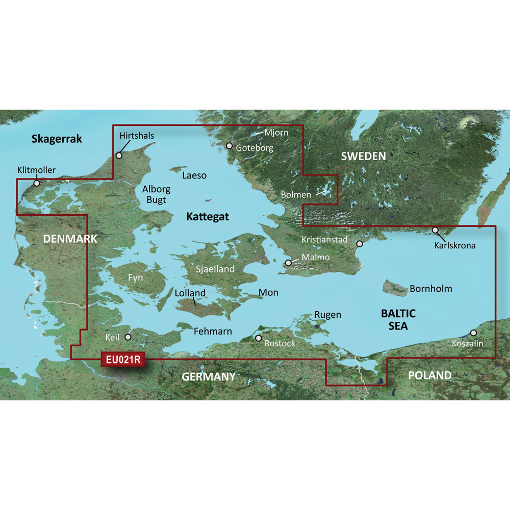
Garmin BlueChart g3 HD - HXEU021R - Denmark East & Sweden Southeast - microSD/SD
Garmin BlueChart g3 HD - HXEU021R - Denmark East & Sweden Southeast - microSD/SD
Online
$129.98for Each
Retail $129.99
Mfr PN: 010-C0777-20
Stock: 10
|
BlueChart® g3 HD - HXEU021R - Denmark East & Sweden Southeast - microSD™/SD™ Coverage: Swedish coast: from Goteborg to Karlskrona, including Malmo and Trelleborg, as well as lakes Mjorn and Bolmen. Danish, German, and Polish coasts: Lemvig, Denmark to Szczecin, Poland, including Limfjorden, Skagen, Den., Copenhagen, Den., Stralsund, Ger., and the islands of Sjaelland, Fyn, Mon, Falster, Lolland, Langeland and Fehmarn. Unparalleled Coastal Chart Coverage
BlueChart g3 coastal charts provide industry-leading coverage, clarity and detail with integrated Garmin and Navionics data. Also included is Auto Guidance1 technology, which uses your desired depth and overhead clearance to calculate routes and provide a suggested path to follow — overlaid onto your chart. NOAA raster cartography is also available as a free downloadable feature via the ActiveCaptain app. It gives your chartplotter paper chartlike views of NOAA-surveyed areas in which individual points of interest are labeled with corresponding longitude and latitude information. Worldwide coverage is available by regions as accessory cards or via download; each region is sold separately. Auto Guidance Technology The Auto Guidance feature¹ calculates a suggested route using your desired depth and overhead clearance. Depth Range Shading This feature displays high-resolution Depth Range Shading for up to 10 depth ranges so you can view your designated target depth. Detailed Contours BlueChart g3 charts feature 1’ contours that provide a more accurate depiction of bottom structure for improved fishing charts and enhanced detail in swamps, canals and port plans. Shallow Water Shading To aid in navigation, Shallow Water Shading allows map shading at a user-defined depth to give a clear picture of shallow waters to avoid. NOAA Raster Cartography This feature gives your chartplotter paper chartlike views of NOAA-surveyed areas in which points of interest are labeled with corresponding longitude and latitude information. ¹Auto Guidance is for planning purposes only and does not replace safe navigation practices. Auto Guidance is not included in preloaded BlueChart g3 for ECHOMAP™ Plus series chartplotters
|
Online
$129.98for Each
Retail $129.99
Mfr PN: 010-C0777-20
Stock: 10
Garmin BlueChart g3 HD - HXEU041R - Oslo - Skagerak - Haugesund - microSD/SD
Garmin BlueChart g3 HD - HXEU041R - Oslo - Skagerak - Haugesund - microSD/SD
Online
$129.98for Each
Retail $129.99
Mfr PN: 010-C0778-20
Stock: 10
|
BlueChart® g3 HD - HXEU041R - Oslo - Skagerak - Haugesund - microSD™/SD™ Coverage: Covers the Norwegian and Swedish coasts from Flekkefjord, Nor. to G, including the Norwegian cities of Kristiansand, Skien, Drammen, Oslo, and Halden. Also includes coverage of the northern most tip of Denmark including Skagen and Frederikshavn, as well as the island of Laeso. Unparalleled Coastal Chart Coverage
BlueChart g3 coastal charts provide industry-leading coverage, clarity and detail with integrated Garmin and Navionics data. Also included is Auto Guidance1 technology, which uses your desired depth and overhead clearance to calculate routes and provide a suggested path to follow — overlaid onto your chart. NOAA raster cartography is also available as a free downloadable feature via the ActiveCaptain app. It gives your chartplotter paper chartlike views of NOAA-surveyed areas in which individual points of interest are labeled with corresponding longitude and latitude information. Worldwide coverage is available by regions as accessory cards or via download; each region is sold separately. Auto Guidance Technology The Auto Guidance feature¹ calculates a suggested route using your desired depth and overhead clearance. Depth Range Shading This feature displays high-resolution Depth Range Shading for up to 10 depth ranges so you can view your designated target depth. Detailed Contours BlueChart g3 charts feature 1’ contours that provide a more accurate depiction of bottom structure for improved fishing charts and enhanced detail in swamps, canals and port plans. Shallow Water Shading To aid in navigation, Shallow Water Shading allows map shading at a user-defined depth to give a clear picture of shallow waters to avoid. NOAA Raster Cartography This feature gives your chartplotter paper chartlike views of NOAA-surveyed areas in which points of interest are labeled with corresponding longitude and latitude information. ¹Auto Guidance is for planning purposes only and does not replace safe navigation practices. Auto Guidance is not included in preloaded BlueChart g3 for ECHOMAP™ Plus series chartplotters
|
Online
$129.98for Each
Retail $129.99
Mfr PN: 010-C0778-20
Stock: 10
Garmin BlueChart g3 HD - HXEU042R - Oslo to Trelleborg - microSD/SD
Garmin BlueChart g3 HD - HXEU042R - Oslo to Trelleborg - microSD/SD
Online
$129.98for Each
Retail $129.99
Mfr PN: 010-C0779-20
Stock: 10
|
BlueChart® g3 HD - HXEU042R - Oslo to Trelleborg - microSD™/SD™ Coverage: Covers the Norwegian and Swedish coasts from Arendal, Nor. to Trelleborg, Swe., including the Norwegian cities of Drammen, Oslo, and Halden and the Swedish cities of Stromstad, Uddevalla, Goteborg, and Stenungsund. Also includes coverage of the Eastern Danish coast from Hirtshals through Copenhagen, as well as the island of Laeso, and lakes Vanern, Vattern, Mjorn, Sommen, Nommen, and Bolmen in Sweden. Unparalleled Coastal Chart Coverage
BlueChart g3 coastal charts provide industry-leading coverage, clarity and detail with integrated Garmin and Navionics data. Also included is Auto Guidance1 technology, which uses your desired depth and overhead clearance to calculate routes and provide a suggested path to follow — overlaid onto your chart. NOAA raster cartography is also available as a free downloadable feature via the ActiveCaptain app. It gives your chartplotter paper chartlike views of NOAA-surveyed areas in which individual points of interest are labeled with corresponding longitude and latitude information. Worldwide coverage is available by regions as accessory cards or via download; each region is sold separately. Auto Guidance Technology The Auto Guidance feature¹ calculates a suggested route using your desired depth and overhead clearance. Depth Range Shading This feature displays high-resolution Depth Range Shading for up to 10 depth ranges so you can view your designated target depth. Detailed Contours BlueChart g3 charts feature 1’ contours that provide a more accurate depiction of bottom structure for improved fishing charts and enhanced detail in swamps, canals and port plans. Shallow Water Shading To aid in navigation, Shallow Water Shading allows map shading at a user-defined depth to give a clear picture of shallow waters to avoid. NOAA Raster Cartography This feature gives your chartplotter paper chartlike views of NOAA-surveyed areas in which points of interest are labeled with corresponding longitude and latitude information. ¹Auto Guidance is for planning purposes only and does not replace safe navigation practices. Auto Guidance is not included in preloaded BlueChart g3 for ECHOMAP™ Plus series chartplotters
|
Online
$129.98for Each
Retail $129.99
Mfr PN: 010-C0779-20
Stock: 10
Garmin BlueChart g3 HD - HXEU043R - Iceland & Faeroe Islands - microSD/SD
Garmin BlueChart g3 HD - HXEU043R - Iceland & Faeroe Islands - microSD/SD
Online
$129.98for Each
Retail $129.99
Mfr PN: 010-C0780-20
Stock: 10
|
BlueChart® g3 HD - HXEU043R - Iceland & Faeroe Islands - microSD™/SD™ Coverage: Includes detailed coverage of all of Iceland including the cities of Reykjavik and Akureyri. Also includes detailed coverage of the Faeroe Islands including Stromo, Ostero, Sydero and Bordo Islands. Unparalleled Coastal Chart Coverage
BlueChart g3 coastal charts provide industry-leading coverage, clarity and detail with integrated Garmin and Navionics data. Also included is Auto Guidance1 technology, which uses your desired depth and overhead clearance to calculate routes and provide a suggested path to follow — overlaid onto your chart. NOAA raster cartography is also available as a free downloadable feature via the ActiveCaptain app. It gives your chartplotter paper chartlike views of NOAA-surveyed areas in which individual points of interest are labeled with corresponding longitude and latitude information. Worldwide coverage is available by regions as accessory cards or via download; each region is sold separately. Auto Guidance Technology The Auto Guidance feature¹ calculates a suggested route using your desired depth and overhead clearance. Depth Range Shading This feature displays high-resolution Depth Range Shading for up to 10 depth ranges so you can view your designated target depth. Detailed Contours BlueChart g3 charts feature 1’ contours that provide a more accurate depiction of bottom structure for improved fishing charts and enhanced detail in swamps, canals and port plans. Shallow Water Shading To aid in navigation, Shallow Water Shading allows map shading at a user-defined depth to give a clear picture of shallow waters to avoid. NOAA Raster Cartography This feature gives your chartplotter paper chartlike views of NOAA-surveyed areas in which points of interest are labeled with corresponding longitude and latitude information. ¹Auto Guidance is for planning purposes only and does not replace safe navigation practices. Auto Guidance is not included in preloaded BlueChart g3 for ECHOMAP™ Plus series chartplotters
|
Online
$129.98for Each
Retail $129.99
Mfr PN: 010-C0780-20
Stock: 10
Garmin BlueChart g3 HD - HXEU046R - Oregrund Aland to Malmo - microSD/SD
Garmin BlueChart g3 HD - HXEU046R - Oregrund Aland to Malmo - microSD/SD
Online
$129.98for Each
Retail $129.99
Mfr PN: 010-C0782-20
Stock: 10
|
BlueChart® g3 HD - HXEU046R - Oregrund Aland to Malmo - microSD™/SD™ Coverage: Detailed coverage of the Southeast coast of Sweden from Oregrund to Copenhagen, Den. Includes detailed coverage of Stockholm and Nykoping, and lakes Sommen, Nommen, and Helgasjon, as well as coverage of the lower Dalalven from Gysinge to Soderfors. Also includes detailed coverage for the islands of Gotland, Oland, and Bornholm, Aland and surrounding islands. Unparalleled Coastal Chart Coverage
BlueChart g3 coastal charts provide industry-leading coverage, clarity and detail with integrated Garmin and Navionics data. Also included is Auto Guidance1 technology, which uses your desired depth and overhead clearance to calculate routes and provide a suggested path to follow — overlaid onto your chart. NOAA raster cartography is also available as a free downloadable feature via the ActiveCaptain app. It gives your chartplotter paper chartlike views of NOAA-surveyed areas in which individual points of interest are labeled with corresponding longitude and latitude information. Worldwide coverage is available by regions as accessory cards or via download; each region is sold separately. Auto Guidance Technology The Auto Guidance feature¹ calculates a suggested route using your desired depth and overhead clearance. Depth Range Shading This feature displays high-resolution Depth Range Shading for up to 10 depth ranges so you can view your designated target depth. Detailed Contours BlueChart g3 charts feature 1’ contours that provide a more accurate depiction of bottom structure for improved fishing charts and enhanced detail in swamps, canals and port plans. Shallow Water Shading To aid in navigation, Shallow Water Shading allows map shading at a user-defined depth to give a clear picture of shallow waters to avoid. NOAA Raster Cartography This feature gives your chartplotter paper chartlike views of NOAA-surveyed areas in which points of interest are labeled with corresponding longitude and latitude information. ¹Auto Guidance is for planning purposes only and does not replace safe navigation practices. Auto Guidance is not included in preloaded BlueChart g3 for ECHOMAP™ Plus series chartplotters
|
Online
$129.98for Each
Retail $129.99
Mfr PN: 010-C0782-20
Stock: 10
Garmin BlueChart g3 HD - HXEU047R - Gulf of Bothnia - Kalix to Grisslehamn - microSD/SD
Garmin BlueChart g3 HD - HXEU047R - Gulf of Bothnia - Kalix to Grisslehamn - microSD/SD
Online
$129.98for Each
Retail $129.99
Mfr PN: 010-C0783-20
Stock: 10
|
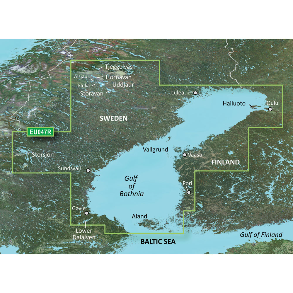
BlueChart® g3 HD - HXEU047R - Gulf of Bothnia - Kalix to Grisslehamn - microSD™/SD™ Coverage: Detailed coverage of the Gulf of Bothnia frome Gavle, Sweden through Pori, Finland, including Oulu and Vaasa, Fin. Sweden coverage includes Lulea Skargard, and lakes Tjeggelvas, Hornavan, Aisjaur, Fluka, Uddjaur, Storavan, and Storsjon well as coverage of the lower Dalalven from Gysinge to Soderfors. Detailed coverage of the islands of Hailuoto, Vallgrund, and Aland is also included. Unparalleled Coastal Chart Coverage
BlueChart g3 coastal charts provide industry-leading coverage, clarity and detail with integrated Garmin and Navionics data. Also included is Auto Guidance1 technology, which uses your desired depth and overhead clearance to calculate routes and provide a suggested path to follow — overlaid onto your chart. NOAA raster cartography is also available as a free downloadable feature via the ActiveCaptain app. It gives your chartplotter paper chartlike views of NOAA-surveyed areas in which individual points of interest are labeled with corresponding longitude and latitude information. Worldwide coverage is available by regions as accessory cards or via download; each region is sold separately. Auto Guidance Technology The Auto Guidance feature¹ calculates a suggested route using your desired depth and overhead clearance. Depth Range Shading This feature displays high-resolution Depth Range Shading for up to 10 depth ranges so you can view your designated target depth. Detailed Contours BlueChart g3 charts feature 1’ contours that provide a more accurate depiction of bottom structure for improved fishing charts and enhanced detail in swamps, canals and port plans. Shallow Water Shading To aid in navigation, Shallow Water Shading allows map shading at a user-defined depth to give a clear picture of shallow waters to avoid. NOAA Raster Cartography This feature gives your chartplotter paper chartlike views of NOAA-surveyed areas in which points of interest are labeled with corresponding longitude and latitude information. ¹Auto Guidance is for planning purposes only and does not replace safe navigation practices. Auto Guidance is not included in preloaded BlueChart g3 for ECHOMAP™ Plus series chartplotters
|
Online
$129.98for Each
Retail $129.99
Mfr PN: 010-C0783-20
Stock: 10
Garmin BlueChart g3 HD - HXEU050R - Aland to Vybord - microSD/SD
Garmin BlueChart g3 HD - HXEU050R - Aland to Vybord - microSD/SD
Online
$129.98for Each
Retail $129.99
Mfr PN: 010-C0786-20
Stock: 10
|
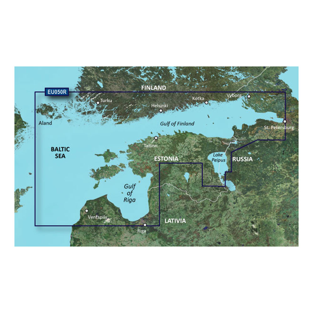
BlueChart® g3 HD - HXEU050R - Aland to Vybord - microSD™/SD™ Coverage: Detailed coverage of the Gulf of Finland from ludes detailed coverage of the cities of Turku, Helsinki, and Kotka in Finland and Tallinn and Kohtla-Jarve in Estonia. Unparalleled Coastal Chart Coverage
BlueChart g3 coastal charts provide industry-leading coverage, clarity and detail with integrated Garmin and Navionics data. Also included is Auto Guidance1 technology, which uses your desired depth and overhead clearance to calculate routes and provide a suggested path to follow — overlaid onto your chart. NOAA raster cartography is also available as a free downloadable feature via the ActiveCaptain app. It gives your chartplotter paper chartlike views of NOAA-surveyed areas in which individual points of interest are labeled with corresponding longitude and latitude information. Worldwide coverage is available by regions as accessory cards or via download; each region is sold separately. Auto Guidance Technology The Auto Guidance feature¹ calculates a suggested route using your desired depth and overhead clearance. Depth Range Shading This feature displays high-resolution Depth Range Shading for up to 10 depth ranges so you can view your designated target depth. Detailed Contours BlueChart g3 charts feature 1’ contours that provide a more accurate depiction of bottom structure for improved fishing charts and enhanced detail in swamps, canals and port plans. Shallow Water Shading To aid in navigation, Shallow Water Shading allows map shading at a user-defined depth to give a clear picture of shallow waters to avoid. NOAA Raster Cartography This feature gives your chartplotter paper chartlike views of NOAA-surveyed areas in which points of interest are labeled with corresponding longitude and latitude information. ¹Auto Guidance is for planning purposes only and does not replace safe navigation practices. Auto Guidance is not included in preloaded BlueChart g3 for ECHOMAP™ Plus series chartplotters
|
Online
$129.98for Each
Retail $129.99
Mfr PN: 010-C0786-20
Stock: 10
Garmin BlueChart g3 HD - HXEU051R - Lista - Sognefjorden - microSD/SD
Garmin BlueChart g3 HD - HXEU051R - Lista - Sognefjorden - microSD/SD
Online
$129.98for Each
Retail $129.99
Mfr PN: 010-C0787-20
Stock: 10
|
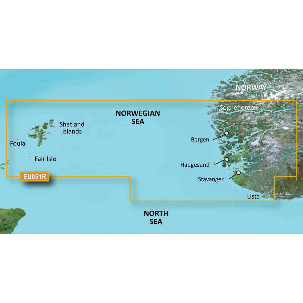
BlueChart® g3 HD - HXEU051R - Lista - Sognefjorden - microSD™/SD™ Coverage: Detailed coverage of the Norway coast from Farsund to Sognefjorden, including the Shetland Islands. Includes detailed coverage of Bergen, Haugesund and Stavanger. Unparalleled Coastal Chart Coverage
BlueChart g3 coastal charts provide industry-leading coverage, clarity and detail with integrated Garmin and Navionics data. Also included is Auto Guidance1 technology, which uses your desired depth and overhead clearance to calculate routes and provide a suggested path to follow — overlaid onto your chart. NOAA raster cartography is also available as a free downloadable feature via the ActiveCaptain app. It gives your chartplotter paper chartlike views of NOAA-surveyed areas in which individual points of interest are labeled with corresponding longitude and latitude information. Worldwide coverage is available by regions as accessory cards or via download; each region is sold separately. Auto Guidance Technology The Auto Guidance feature¹ calculates a suggested route using your desired depth and overhead clearance. Depth Range Shading This feature displays high-resolution Depth Range Shading for up to 10 depth ranges so you can view your designated target depth. Detailed Contours BlueChart g3 charts feature 1’ contours that provide a more accurate depiction of bottom structure for improved fishing charts and enhanced detail in swamps, canals and port plans. Shallow Water Shading To aid in navigation, Shallow Water Shading allows map shading at a user-defined depth to give a clear picture of shallow waters to avoid. NOAA Raster Cartography This feature gives your chartplotter paper chartlike views of NOAA-surveyed areas in which points of interest are labeled with corresponding longitude and latitude information. ¹Auto Guidance is for planning purposes only and does not replace safe navigation practices. Auto Guidance is not included in preloaded BlueChart g3 for ECHOMAP™ Plus series chartplotters
|
Online
$129.98for Each
Retail $129.99
Mfr PN: 010-C0787-20
Stock: 10
Garmin BlueChart g3 HD - HXEU052R - Sognefjorden - Svefjorden - microSD/SD
Garmin BlueChart g3 HD - HXEU052R - Sognefjorden - Svefjorden - microSD/SD
Online
$129.98for Each
Retail $129.99
Mfr PN: 010-C0788-20
Stock: 10
|
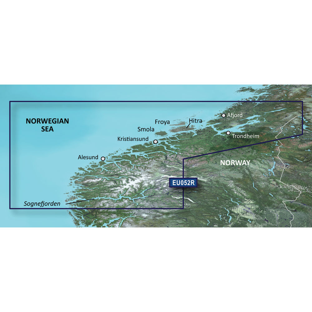
BlueChart® g3 HD - HXEU052R - Sognefjorden - Svefjorden - microSD™/SD™ Coverage: Includes detailed coverage of the Norway coast from Sognefjorden to Afjord. Also includes detailed coverage of Alesund, Kristiansund, Hitra and Trondheim. Unparalleled Coastal Chart Coverage
BlueChart g3 coastal charts provide industry-leading coverage, clarity and detail with integrated Garmin and Navionics data. Also included is Auto Guidance1 technology, which uses your desired depth and overhead clearance to calculate routes and provide a suggested path to follow — overlaid onto your chart. NOAA raster cartography is also available as a free downloadable feature via the ActiveCaptain app. It gives your chartplotter paper chartlike views of NOAA-surveyed areas in which individual points of interest are labeled with corresponding longitude and latitude information. Worldwide coverage is available by regions as accessory cards or via download; each region is sold separately. Auto Guidance Technology The Auto Guidance feature¹ calculates a suggested route using your desired depth and overhead clearance. Depth Range Shading This feature displays high-resolution Depth Range Shading for up to 10 depth ranges so you can view your designated target depth. Detailed Contours BlueChart g3 charts feature 1’ contours that provide a more accurate depiction of bottom structure for improved fishing charts and enhanced detail in swamps, canals and port plans. Shallow Water Shading To aid in navigation, Shallow Water Shading allows map shading at a user-defined depth to give a clear picture of shallow waters to avoid. NOAA Raster Cartography This feature gives your chartplotter paper chartlike views of NOAA-surveyed areas in which points of interest are labeled with corresponding longitude and latitude information. ¹Auto Guidance is for planning purposes only and does not replace safe navigation practices. Auto Guidance is not included in preloaded BlueChart g3 for ECHOMAP™ Plus series chartplotters
|
Online
$129.98for Each
Retail $129.99
Mfr PN: 010-C0788-20
Stock: 10
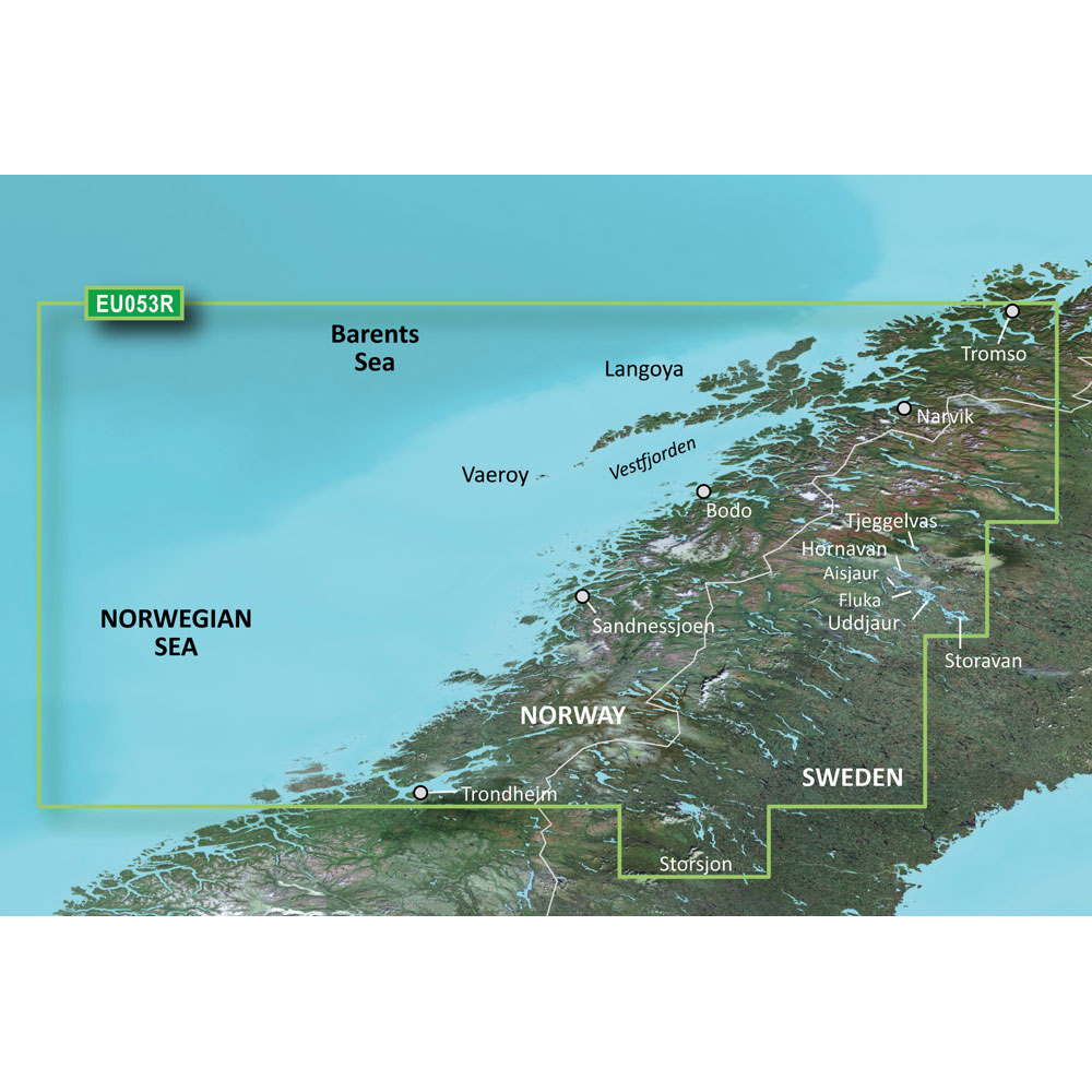
Garmin BlueChart g3 HD - HXEU053R - Trondheim - Tromso - microSD/SD
Garmin BlueChart g3 HD - HXEU053R - Trondheim - Tromso - microSD/SD
Online
$129.98for Each
Retail $129.99
Mfr PN: 010-C0789-20
Stock: 10
|
BlueChart® g3 HD - HXEU053R - Trondheim - Tromso - microSD™/SD™ Coverage: Detailed coverage of the Norway coast from Trondheim to Tromso. Includes detailed coverage for Sandnessjoen, Bodo, Vaeroy, Langoya, Narvik, and Vestfjorden, as well as lakes Tjeggelvas, Hornavan, Uddjaur, Aisjaur, Fluka, Storavan, and Storsjon. Unparalleled Coastal Chart Coverage
BlueChart g3 coastal charts provide industry-leading coverage, clarity and detail with integrated Garmin and Navionics data. Also included is Auto Guidance1 technology, which uses your desired depth and overhead clearance to calculate routes and provide a suggested path to follow — overlaid onto your chart. NOAA raster cartography is also available as a free downloadable feature via the ActiveCaptain app. It gives your chartplotter paper chartlike views of NOAA-surveyed areas in which individual points of interest are labeled with corresponding longitude and latitude information. Worldwide coverage is available by regions as accessory cards or via download; each region is sold separately. Auto Guidance Technology The Auto Guidance feature¹ calculates a suggested route using your desired depth and overhead clearance. Depth Range Shading This feature displays high-resolution Depth Range Shading for up to 10 depth ranges so you can view your designated target depth. Detailed Contours BlueChart g3 charts feature 1’ contours that provide a more accurate depiction of bottom structure for improved fishing charts and enhanced detail in swamps, canals and port plans. Shallow Water Shading To aid in navigation, Shallow Water Shading allows map shading at a user-defined depth to give a clear picture of shallow waters to avoid. NOAA Raster Cartography This feature gives your chartplotter paper chartlike views of NOAA-surveyed areas in which points of interest are labeled with corresponding longitude and latitude information. ¹Auto Guidance is for planning purposes only and does not replace safe navigation practices. Auto Guidance is not included in preloaded BlueChart g3 for ECHOMAP™ Plus series chartplotters
|
Online
$129.98for Each
Retail $129.99
Mfr PN: 010-C0789-20
Stock: 10
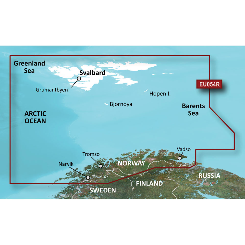
Garmin BlueChart g3 HD - HXEU054R - Vestfjd - Svalbard - Varanger - microSD/SD
Garmin BlueChart g3 HD - HXEU054R - Vestfjd - Svalbard - Varanger - microSD/SD
Online
$129.98for Each
Retail $129.99
Mfr PN: 010-C0790-20
Stock: 10
|
BlueChart® g3 HD - HXEU054R - Vestfjd - Svalbard - Varanger - microSD™/SD™ Coverage: Detailed coverage of the northern Norway coast from Vestfjorden to Vadso including Tromso and Narvik. Also includes coverage for Svalbard and approaches. Unparalleled Coastal Chart Coverage
BlueChart g3 coastal charts provide industry-leading coverage, clarity and detail with integrated Garmin and Navionics data. Also included is Auto Guidance1 technology, which uses your desired depth and overhead clearance to calculate routes and provide a suggested path to follow — overlaid onto your chart. NOAA raster cartography is also available as a free downloadable feature via the ActiveCaptain app. It gives your chartplotter paper chartlike views of NOAA-surveyed areas in which individual points of interest are labeled with corresponding longitude and latitude information. Worldwide coverage is available by regions as accessory cards or via download; each region is sold separately. Auto Guidance Technology The Auto Guidance feature¹ calculates a suggested route using your desired depth and overhead clearance. Depth Range Shading This feature displays high-resolution Depth Range Shading for up to 10 depth ranges so you can view your designated target depth. Detailed Contours BlueChart g3 charts feature 1’ contours that provide a more accurate depiction of bottom structure for improved fishing charts and enhanced detail in swamps, canals and port plans. Shallow Water Shading To aid in navigation, Shallow Water Shading allows map shading at a user-defined depth to give a clear picture of shallow waters to avoid. NOAA Raster Cartography This feature gives your chartplotter paper chartlike views of NOAA-surveyed areas in which points of interest are labeled with corresponding longitude and latitude information. ¹Auto Guidance is for planning purposes only and does not replace safe navigation practices. Auto Guidance is not included in preloaded BlueChart g3 for ECHOMAP™ Plus series chartplotters
|
Online
$129.98for Each
Retail $129.99
Mfr PN: 010-C0790-20
Stock: 10
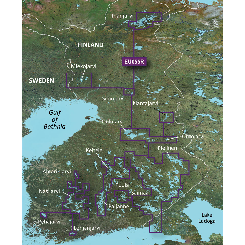
Garmin BlueChart g3 HD - HXEU055R - Finnish Lakes - microSD/SD
Garmin BlueChart g3 HD - HXEU055R - Finnish Lakes - microSD/SD
Online
$129.98for Each
Retail $129.99
Mfr PN: 010-C0791-20
Stock: 10
|
BlueChart® g3 HD - HXEU055R - Finnish Lakes - micorSD™/SD™ Coverage: Detailed coverage of inland Finnish lakes including Inarijarvi, Miekojarvi, Simojarvi, and Kiantajarvi. Also includes detailed coverage of Oulujarvi, Pielinen, Saimaa, Paijanne, Nasijarvi, Lohjanjrvi, and others. Unparalleled Coastal Chart Coverage
BlueChart g3 coastal charts provide industry-leading coverage, clarity and detail with integrated Garmin and Navionics data. Also included is Auto Guidance1 technology, which uses your desired depth and overhead clearance to calculate routes and provide a suggested path to follow — overlaid onto your chart. NOAA raster cartography is also available as a free downloadable feature via the ActiveCaptain app. It gives your chartplotter paper chartlike views of NOAA-surveyed areas in which individual points of interest are labeled with corresponding longitude and latitude information. Worldwide coverage is available by regions as accessory cards or via download; each region is sold separately. Auto Guidance Technology The Auto Guidance feature¹ calculates a suggested route using your desired depth and overhead clearance. Depth Range Shading This feature displays high-resolution Depth Range Shading for up to 10 depth ranges so you can view your designated target depth. Detailed Contours BlueChart g3 charts feature 1’ contours that provide a more accurate depiction of bottom structure for improved fishing charts and enhanced detail in swamps, canals and port plans. Shallow Water Shading To aid in navigation, Shallow Water Shading allows map shading at a user-defined depth to give a clear picture of shallow waters to avoid. NOAA Raster Cartography This feature gives your chartplotter paper chartlike views of NOAA-surveyed areas in which points of interest are labeled with corresponding longitude and latitude information. ¹Auto Guidance is for planning purposes only and does not replace safe navigation practices. Auto Guidance is not included in preloaded BlueChart g3 for ECHOMAP™ Plus series chartplotters
|
Online
$129.98for Each
Retail $129.99
Mfr PN: 010-C0791-20
Stock: 10
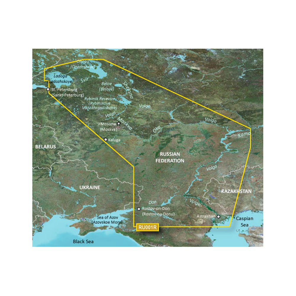
Garmin BlueChart g3 HD - HXEU062R - Russian Inland Waterways - microSD/SD
Garmin BlueChart g3 HD - HXEU062R - Russian Inland Waterways - microSD/SD
Online
$129.98for Each
Retail $129.99
Mfr PN: 010-C1048-20
Stock: 10
|
BlueChart® g3 HD - HXEU062R - Russian Inland Waterways - microSD™/SD™ Coverage: This Cyrillic data card details main channel coverage of the major river systems and lakes of western Russia. Detailed coverage includes the Don R. from the Sea of Azov (Azovskoe More) to the Tsimlyanskoe Reservoir (Tsimlyansk Vodokhranilishche); the Volga-Don Canal (Volgo-Donskoy Kanal) to the Volga R. which is shown in its entirety; the Kama R. from Tyul'kino to the Volga R.; the Vishera R. from Ryabinino to the junction with the Kama R.; the Oka R. from Kaluga to its junction with the Moskva R; the Sheksna R. in its entirety; Lake Beloe (Beloye Ozero); the Volga-Baltic Canal (Volgo-Baltiyskiy Kanal); Lake Onega (Onezhskoe Ozero); the Svir R. to Lake Ladoga (Ladozhskoye Ozero); and the Neva R. to St. Petersburg (Sankt-Peterburg). Also included are the Volga-Baltic Waterway including the Rybinsk Reservoir (Rybinskoye Vodokhranilishche), the entire White Sea-Baltic Canal, and Lakes Onega (Onezhskoe), Ladoga (Ladozhskoye), and Beloe (Beloye). Unparalleled Coastal Chart Coverage
BlueChart g3 coastal charts provide industry-leading coverage, clarity and detail with integrated Garmin and Navionics data. Also included is Auto Guidance1 technology, which uses your desired depth and overhead clearance to calculate routes and provide a suggested path to follow — overlaid onto your chart. NOAA raster cartography is also available as a free downloadable feature via the ActiveCaptain app. It gives your chartplotter paper chartlike views of NOAA-surveyed areas in which individual points of interest are labeled with corresponding longitude and latitude information. Worldwide coverage is available by regions as accessory cards or via download; each region is sold separately. Auto Guidance Technology The Auto Guidance feature¹ calculates a suggested route using your desired depth and overhead clearance. Depth Range Shading This feature displays high-resolution Depth Range Shading for up to 10 depth ranges so you can view your designated target depth. Detailed Contours BlueChart g3 charts feature 1’ contours that provide a more accurate depiction of bottom structure for improved fishing charts and enhanced detail in swamps, canals and port plans. Shallow Water Shading To aid in navigation, Shallow Water Shading allows map shading at a user-defined depth to give a clear picture of shallow waters to avoid. NOAA Raster Cartography This feature gives your chartplotter paper chartlike views of NOAA-surveyed areas in which points of interest are labeled with corresponding longitude and latitude information. ¹Auto Guidance is for planning purposes only and does not replace safe navigation practices. Auto Guidance is not included in preloaded BlueChart g3 for ECHOMAP™ Plus series chartplotters
|
Online
$129.98for Each
Retail $129.99
Mfr PN: 010-C1048-20
Stock: 10
|
|
|
|
Copyright © 2009-2024 A part of the Intelastores, Inc. Store Network Site Designed and Maintained by Inline Internet Systems, Inc. |